the histories of our streets

Georgia State University students map Atlanta's past

Month: February 2024

The Most Inconspicuous Monument in Downtown Atlanta

I pass by this monument everyday coming onto campus (the bus I take to campus lets us off just one block down from it). But the first time I really ever noticed it was on the “Women in Downtown Atlanta” walking tour with Amy Durrell that I went on for this course.

Selfie of the author with the Barbara Miller Asher statue in Downtown Atlanta

Barbara Miller Asher and I

The monument is a representation of Barbara Miller Asher. She gained community favor through 14 years of volunteer work and was elected to her first term as a city council member in Atlanta in 1977, serving multiple terms.1 The statue commemorating her is located on the intersection of Marietta St. NW and Broad St. NW in front of Broad Street Plaza.

I’m of the opinion that women should be taken much more seriously in history, and the records we have for women’s accomplishments and impacts should be under much more scrutiny. Barbara Miller Asher is no exception. I was almost able to find more information on the building of this monument and her marriage to her husband than I was on her achievements. Commemorating doesn’t even feel like the right word to describe the presence of a statue in her likeness. To me, it feels like more of just an acknowledgement that she existed.

I can’t help but compare the depictions of a woman to the depictions of a man. I believe it is very indicative to the culture’s attitude of women’s role in society. Here, while Barbara Miller Asher is at street-level, Henry Grady’s likeness (only one block down, also on Marietta St. NW) is much grander, being several feet above the road and holding a godlike stature above two women who look meek and in need of protecting. Barbara looks much more inviting. I’ve noticed that she has a smile on her face, her knees being bent makes her look less intimidating, and overall she just seems very welcoming. To me, her monument is a reminder that women are people, while statues commemorating men display that they get to assume the role of something more than that.

Since that walking tour, I know I’ll never be able to come to the Georgia State University campus without thinking of Barbara Miller Asher and women’s inescapable relegation to the background. In a way, her newfound prominence in my mind is already a stride in defeating that social norm.

  1. “Asher, Barbara Miller, November 20, 1985.” The Breman Museum , November 20, 1985. https://archivesspace.thebreman.org/repositories/2/archival_objects/27944. ↩︎

Historical Collins Street

Back in 1870 to 1910, Collins Street was historic for its home to Atlanta’s very own “red-light district”. Where I am standing in the picture was once a place lined with Madame-led brothels and businesses that were run by many people of different races and culture backgrounds. I often walk past and through this street without even thinking that this walkway would have its own special history. This location is interesting to me since its right in the middle of GSU and people easily overlook such a historical location.

In an area that was considered a “melting pot” of different racial backgrounds, racial segregation still prevailed in this small area. Despite the area being known for multiculturism, segregation still had a strong grip on the people of Collins Street. Sadly, property values within Collins Street were low, primarily due to the concentration of Black individuals living on Collins Street. The evaluation of the property there shined a light on the ongoing discrimination that perpetuated the social injustice within the community.

The brothels along Collins Street were looked down upon by the city of Atlanta. However, the only way that prostitution was able to continue in the city was as long as it stayed exclusively along Collins Street. Right behind Collins Street was the railroad, which helped with the boom of business. Even though the brothels along Collins Street was not embraced by everyone, city directories still considered the brothels an established business. In regard to the women working in the brothels, they were all different races. But according to census back in the late 1800s, madams and prostitutes were deemed white along with mixed race women too.1 Collins Street prevailed for 40 years. But its downfall was the Courtland Street viaduct bridge. The bridge ran right above Collins Street. Young schoolboys and girls would take the bridge route to school, which overlooked the Collins Street.2 In 1910 due to the worries of tainting the youth, Collins Street brothels were closed. In the mid 1900s, Georgia State expanded its campus via the urban renewal plan, taking over Collins Street.

  1. Dr. Mandy Swygart-Hobaugh, “Historic Harlots of Old Atlanta. “Historic Harlots of Old Atlanta (arcgis.com) (accessed February 22, 2024) ↩︎
  2. Harvey K. Newman, “Decatur Street: Atlanta’s African American Paradise Lost.” Atlanta History, vol 64 (Summer 2000), 5-20 ↩︎

Historic Downtown Streets Installation in front of the William-Oliver Building

I was introduced to the William-Oliver Building during my freshman year when one of my friends lived there, it always stood out to me for its sense of opulence in an otherwise industrial-looking block. As an environmental science major with an interest in urban planning, I am at times hyper-aware of the built environment and curious about its histories such as why infrastructure like streets developed and how. Continuing my education this kind of information did not always feel readily available – looking for further history on land use in the area I was drawn back to the William-Oliver Building where I noticed a large plaque structure for the first time.

Student Selfie at downtown street history Installation
Student Selfie at Historic Downtown Streets Plaque Installation outside of William-Oliver Building

The installation is located across Peachtree St. from Hurt Park and features five panels including brief histories on Peachtree St., Marietta St., Whitehall St., Decatur St., and Edgewood Ave. – some of the most crucial roadways to Downtown. Each panel provides the street’s name and timelines, mostly dated back to the early 1800s, as well as the street’s past functions as indigenous routes or intra/inner city connectors. It seems to be one of the few places nearby that acknowledges (although incorrectly) the indigenous Muscogee-Creek Peoples that once lived in the region or their land uses. The “Peachtree Street” panel specifically provides information on the Peachtree Ridge, dubbed such by indigenous inhabitants, that the city expanded from. I have since learned that the indigenous-given name for the region surrounding the ridge, “Standing Peachtree”, was changed in the early 1800s when indigenous groups were forcibly removed by settlers and indigenous-erasure campaigns were executed. Such information is critical to understanding the socio-environmental history before colonialism, indigenous land use, and their impacts on modern development patterns.

Partially hidden from streetview, the plaque appears more historic and official than others I have seen due to its unique engraved metal structure. It is, however, visually similar to one nearby art installation (directly to the left of that discussed on the “island” on Peachtree St.) at the site of what was once a municipal well that provided water resources to the settlement of Terminus in the 1800s. The art piece provides no indication of this history or any relation to the installation at hand and they may have both been installed in preparation for the 1996 Olympic Games held in the city.

Regardless of when the historic downtown streets plaque was installed the provision of such information in a public space feels crucial to education on urban development and a good start towards more accurate historical representation. I find the understanding of how and why our travel paths and geographic resource use developed to be crucial in having a holistic understanding of concerns such as urban renewal and cultural preservation. There are still four panels on Downtown Street history not pictured here so if you’re curious to learn more I recommend stopping by and checking it out!

The Hub at Peachtree Center

Me inside of The Hub

Within the Peachtree Center District in downtown Atlanta, many working Atlantans throughout the area visit a small, partially underground food court known as the Hub at Peachtree Center, which offers a variety of restaurant and retail services as well as other amenities. This frequently visited food court is located between Peachtree Street and Peachtree Center Avenue, easily accessible from the nearby MARTA station. The Hub is surrounded by several office buildings with pedestrian walkways that connect directly to the food court, providing businesses with convenient access to the numerous available services offered.

The Hub was designed by architect John C. Portman, who also designed many of the adjacent office buildings and hotels along with most of the high rises in the Peachtree Center District, contributing greatly to the transformation in Atlanta’s skyline in the 1960s. Due to challenges in its aging infrastructure, the mall underwent several renovations over the last three decades, with the goal of reinstituting the outdated food court to a central gathering location for the millions of annual visitors staying in surrounding hotels.

This site is particularly interesting to me because I often walk here to eat lunch before my next class, and it has become a regular location in my daily schedule. Also, a scene from one of my favorite movies, Baby Driver, was filmed here in 2017, in addition to various parts of the GSU campus as well as other areas in downtown.

The Five Points Monument

Me in front of the five points monument

As a GSU student I pass this on a daily basis on my way to class and for the longest time I’ve paid it no mind. I’m certain that anyone trying to get anywhere in a timely fashion isn’t going to pay attention to it either (considering that they put it in the middle of a crosswalk I think this may have been intentional). Recently however I’ve stopped to look at this statue and was left wondering, “what am I even looking at?” and “Why is this here?” To my surprise there’s more to this weird looking structure than meets the eye.

This statue is Called the Five points monument it was built in 1996 by George Beasley during the lead up to the Centennial Olympic games. It was built to commemorate the 5 streets that intersect to form the heart of Atlanta, where trolly tracks and an artisan water tower stood. To my surprise this weird looking structure is supposed to be Beasley’s interpretation of that same water tower. To be more specific the statue is an asymmetric interpretation of the water tower’s traditional girder construction, the steel trusses that make up its structure represent the trolley tracks buried under the street.

The statue was initially created at the studio at Georgia State before being moved to its current location by a couple flat bet trucks. To get to its location on time, the development of this statue was rushed with it being installed just a week before the Olympics. Its fascinating to me that a statue with this much meaning and history is placed in such a questionable, unassuming spot: a pedestrian island. It makes me wonder how many other monuments are hidden in plain sight.

The Candler Building

As you’re walking around Downtown Atlanta, it’s easy for many of us to miss many of the buildings towering over you as you walk to your next destinations. However, one building that has always stood out to me personally has been the Candler Building for many reasons.

Standiing in front of the north side of the Candler Building

The Candler Building was built in 1906 by the Coca Cola founder Asa Griggs Candler, and features many unique design choices that make it stand out in the landscape. It was the tallest building in the City of Atlanta at the time, with 17 stories, making it tower over the city landscape and surrounding buildings such as the Flatiron Building, built only a few years prior in 1897. This makes the Candler Building one of the first among many of the skyscrapers and towers we see and pass by every day in Downtown Atlanta.

Today, it’s situated next to the Georgia State University College of Law, and only a block away from Woodruff Park and Aderhold Learning Center and the Peachtree Corners MARTA station, among other things. It is impossible to miss when walking around the Woodruff Park and Five Points area because of its unique V shape and its nature of towering over the area. I’m sure almost every Georgia State student, myself very much included, has looked at and observed this building at some point in walking around the area.

It also has a unique design and art style surrounding it that I’ve always found interesting to look at and observe, which helps make it stand out from a lot of other buildings in and around the area, a lot of which are boring or don’t have much in the way of detailed character to them, in my opinion. It’s also an important relic that still stands in the city skyline from over a century ago, which helps draw the eye to it even more in a city landscape dominated by a mix of buildings built and designed throughout the last 100 years.

The Building had many uses over the years, including serving as a high class hotel, hosting restaurants and serving as the headquarters for the Central Bank & Trust, also owned by Candler. This bank eventually merged into what would become the precursor to the Bank of America, showing the kind of history that this building holds in the city.

Either way, I think that this building serves as a very important historical marker in the city of Atlanta and it’s evolving landscape, and I think that the design and style of the building has always been some kind of a point of attraction or point of interest for me as I walk around the downtown area.

Alonzo F. Herndon’s Barber Shop

Selfie taken in front of the modern front entrance to Herndon's barber shop.

Alonzo Herndon was Atlanta’s first African American millionaire and was an affluent businessman during the late 1800’s into the early 1900’s. He owned and operated multiple businesses including his barber shop: the Crystal Palace located at 66 Peachtree Street in the city’s business district.

I chose this location for my journal entry because I have walked past this shop front for many years, starting in 2009. However, it was not until recently that I began to think more deeply about the buildings and the people that once visited and lived inside of them.

When I was first exposed to the story of Alonzo Herndon, his business and affluence, did my fascination with this property and Herndon grow.

Born into slavery Herndon was the son of his mother’s enslaver. After the Civil war was over he moved away with his mother and siblings where they would make a living sharecropping. Herndon had a knack for business and earned secondary income as a peddler of small goods including peanuts and axel grease.1 After saving enough money Herndon would eventually move to Atlanta where he would become business partners with other affluent black Atlantans. It was those partnerships that led Herndon to have the opportunity to open up his Crystal Palace.

Unfortunately, Herndon’s business was a victim of the 1906 riot and eventual massacre. He was fortunate enough to have been home that night however, his business was targeted and vandalized. After the massacre and destruction of the Crystal Palace, Herndon decided to stay and continue to build his business enterprise. While the torching of his barbershop was a major setback, in regards to race relations, Herndon was more concerned about the success of his insurance company and other ventures.

It is important to remember however, that despite his ability to survive and grow, Herndon’s existence was never easily or mutually accepted. By existence, it is meant: a black man in the early 1900’s who is successful, socially rejected, yet economically accepted.

  1. Henderson, Alexa. “Alonzo Herndon.” New Georgia Encyclopedia, last modified Jul 14, 2020. (Accessed Feb 20, 2024.) https://www.georgiaencyclopedia.org/articles/business-economy/alonzo-herndon-1858-1927/ ↩︎

My Walk by the Walton-Forsyth Building

Forsyth-Walton Building

The Forsyth-Walton Building caught my eye because it is almost hidden within all the more modern skyscrapers of Atlanta. It gives a glance at what old Atlanta structures were like, lower to the ground with two floors, retail shops at the bottom with office space on top, or perhaps a living space. I knew the building had some age, but it came to my surprise when I found out it was constructed in 1900. It was revamped in 1936, adding an Art Deco façade to its exterior. Other than this, I couldn’t find much else about the building other than it being under threat of demolition temporarily but found to be under no threat.

Passing by the building gives the sense that it had a lot of character, maybe because it was so different from the rest. The Farlie-Poplar historic district has many buildings from different periods and many from the same. Many buildings had a similar feel, and the area seemed surprisingly quiet and almost peaceful. The area is somewhat of a tiny reflection of Atlanta’s past. It’s like a little collage of different time periods.

Investigating this area gave me a lot of enjoyment because it isn’t an area I would have thought to explore. Except when we were on our last walking tour, I saw the Forsyth-Walton Building. It made me curious about what other types of buildings like it are hidden within plain sight. Especially with a growing city like Atlanta, it makes me want to find more since it could possibly be the last time, considering Atlanta’s trend regarding historic areas. I plan to explore this area and search for other parts of Atlanta with historic buildings. Plus, having a little walk is always super friendly and refreshing.

A New Beginning at Kile’s Corner

Author is standing right in front of the plaque signifying Kile's Corner.
Close-up of the “Kile’s Corner” plaque.
This is a wide shot of the intersection of Marietta and Edgewood. In the background, one can spot the plaque although it nearly blends into the urban environment.
Wide shot of the plaque on the intersection of Marietta and Edgewood.

At the crossroads of two busy downtown streets lies a not so insignificant marker of early Atlantan history. To the untrained eye, it’s nearly imperceptible. The above image captures the William Oliver Condo building, and towards the western side of the building is a humble plaque. On closer inspection, the details are rather sparse: this plaque signifies the original location of a store owned by a Mr. Thomas Kile where the first municipal election took place in 1848. Originally, this grabbed my attention because I wanted to know more about the city’s history before the Civil War. Who could have known that such an occasion would warrant only a small marker and not something more eye-catching?

Atlanta at the time of the election was not yet even ten years old. Founded in 1837, the city was the junction for the Western and Atlantic, Georgia, and Macon and Western Railroads.1 One day, Atlanta would grow into a larger railroad hub, but in those days, the city would have looked unrecognizable not only to 21st-century residents but also to folks after Reconstruction. The fall before the 1848 election, a Mr. William N. White from New York state resided in Atlanta for three months and documented his experiences in his diary and private letters. According to his account, the built environment was modest, to say the least. All 2,500 residents lived in a “city” with no churches but had two small schools, two hotels, 30 stores, and three newspapers. Surprisingly, Atlanta in late 1847 had yet to elect a city government, so one can imagine the rough character of a place where “everyone does what is right in his own eyes.” Nevertheless, Mr. White surely had a memorable, albeit short, stay in a state he deems the “Italy of America”: comfortably warm in its climate and in the temperament of its people.2

On January 29, 1848, 215 eligible voters casted their votes to elect Atlanta’s first mayor and six city council members. Mr. Moses W. Formwalt who was a tinner by profession emerged victorious as the new mayor and reportedly served the city well for his one-year term. For the longest time, his grave in Oakland Cemetery not only suffered from neglect but also had no distinguishing grave markers. It wasn’t until late 1916 when a proper granite monument was erected in Formwalt’s honor.3

Atlanta may have changed greatly since Mayor Formwalt’s time, but vestiges of past eras remain embedded in the city we now call home.

  1. Ambrose, Andy. “Atlanta.” New Georgia Encyclopedia, last modified Jun 8, 2022. https://www.georgiaencyclopedia.org/articles/counties-cities-neighborhoods/atlanta/; Timothy J. Crimmins, “The Atlanta Palimpsest: Stripping Away the Layers of the Past,” Atlanta Historical Journal 26, no. 2-3 (Summer-Fall 1982): 30 ↩︎
  2. “Early Days of Atlanta as Described in Diary of Pioneer: City Had No Government, Not Even a Church, Before Election of Moses Form Walt, Its First Mayor, to Whom Monument Was Unveiled Last Week. Early Days of Atlanta as Described in Diary,” The Atlanta Constitution (1881-1945), November 26, 1916, sec. MAGAZINE SECTION, https://www.proquest.com/docview/496858263/abstract/30BDE9606B11440EPQ/1. ↩︎
  3. “COMMITTEE IS TO HUNT FOR DEAD MAN: Grave of Atlanta’s First Mayor to Be Located. MONUMENT WILL BE REARED Councilman Holland Will Introduce the Necessary Resolution. MOSES W. FOOMWALT WAS FIRST MAYOR No Headstone Marks the Spot Where This First Mayor of Atlanta Was Buried.,” The Atlanta Constitution (1881-1945), April 28, 1900, https://www.proquest.com/docview/495581992/abstract/8712A4BD5DF543D0PQ/1; “LAST RESTING PLACE OF THE FIRST MAYOR LOCATED IN OAKLAND: Grave of Moses W. Formwalt, Atlanta’s First Chief Executive, Found through Aid of P. H. Bell, an Atlanta Lawyer.,” The Atlanta Constitution (1881-1945), March 17, 1907, sec. C, https://www.proquest.com/docview/496111046/abstract/9E1E83A42F18402EPQ/1; “Monument Is Unveiled Wednesday In Honor of City’s First Mayor,” The Atlanta Constitution (1881-1945), November 23, 1916, https://www.proquest.com/docview/496858826/abstract/229783318584FDFPQ/1. ↩︎

Grady Memorial Hospital

Grady Memorial was founded in 1890. It first opened in 1892 in a small building that still stands today. It was named after Henry W. Grady. The hospital started with fourteen rooms and expanded over the years. The hospital had several locations, including Georgia Hall, Butler Hall, and Hirsch Hall. At one point, the hospital was segregated and divided areas by gender. Today, Grady Memorial Hospital is considered one of the largest hospitals in Atlanta.

This image has an empty alt attribute; its file name is IMG_9515-1-cb8d208c2bbc469c.jpg

The Grady Memorial is located at 80 Jesse Hill Jr Dr SE, Atlanta, GA 30303. This is the biggest hospital visible in the Atlanta area. Many people go there for checkups and services. I was born in this hospital (Grady Baby). I know many people who were born here including my siblings, cousins, and friends. As a kid, I would always come to this hospital for check-ups and afterward would walk around the city with my mother. During my high school years, I would sometimes walk from my school passing the hospital to reach the Georgia State Marta Station. The Marta Station is nearby so there is easy access to transportation. I took my selfie from the upper level of the GSU parking lot , which displays me and the hospital in the background. The thing that amazes me is how big this hospital is getting. Many new facilities are being built around the hospital and expanding. I have so many sweet memories as a child of this place and hope that this hospital continues to give services to the city of Atlanta.

Walkway Arch

This arch doesn’t have an exact address, but it is located through the narrow path that connects Peachtree St. NW. Woodruff Park stands east of it, Flatiron City building directly north, and a Moe’s Southwest Grill lies directly south. GSU students often pass this structure on the way to Aderhold Building. I glimpsed on one bottom side of the arch as I passed by and read Chick-Fil-A twice and small print which look like what would be list of names. I noticed this structure because of the colorful flowers attached, which looks like it has been on there since recently because the latest up-to-date street view was in September 2023.

Selfie at the arch with flowers
Slightly blurry selfie walking pass the arch.

I think the flowers on the arch are a cute touch. Most places in downtown are gray, bland, and boring. In my opinion, there should be more colors in the downtown landscape, the concrete gray can be so depressing. The pop of color and nature brings a little life as go on about our day. I do very much appreciate the little details in things like this that is a vibrant contrast to the concrete jungles in the downtown landscape.

Centennial Olympic Park

Centennial Olympic Park is one of my favorite parts about Downtown Atlanta. Nestled in the heart of the city, this park is absolutely beautiful. This place is so special to me because it represents peacefulness and quietness. As I take my weekly stroll throughout the park, I feel like I’m in a totally different environment than the loud and aggressive environment a few city blocks away. I see families laughing, kids rolling around in the grass, and everyone just enjoying a beautiful day in the city of Atlanta.

Another thing this park represents is its history. Built in 1996 for the Centennial Summer Olympic games, it shows just how much Atlanta has become a world-class city. It’s so cool to walk a few city blocks and enter a space that has been visited by millions of people all over the globe by not just the 1996 Summer Games but currently today. The park is connected to Atlanta’s best attractions, including the World of Coca-Cola and the Georgia Aquarium. It also hosts Atlanta’s massive events, including the NFL experience for Super Bowl LIII in 2019. As a visitor during Super Bowl week, it was amazing to see so many fans visiting this park from all over the world.

Lastly, this park represents how much Atlanta has grown over the past thirty years. As I see the Midtown skyline, I catch a glimpse of all the construction and tall buildings being built. I see all of the commercial development that has surrounded the park in the last few years including the Wyndham hotel and the Sky view Ferris wheel. This park has given both locals and tourists a place to rewind, relax, and be reminded of Atlanta’s legacy.

Flame of Freedom

Flame of Freedom
Me in front of the Flame of Freedom

The Flame of Freedom stands at the corner of Martin Luther King Jr Drive SE and Piedmont Ave SW. It was presented and raised by the American Legion on March 15, 1969. It is dedicated to all the service members who served in the U.S. military. I used to pass this monument a lot when I would walk to campus. I think it is a nice way to commemorate those who served and thank those currently serving.

The Flame of Freedom is a part of the bigger Pete Wheeler Georgia War Veterans Memorial. It was dedicated in 1998. Pete Wheeler is a World War II veteran and long time commissioner for the Georgia Department of Veterans Affairs. It has plaques with the names of all the Georgia veterans who lost their lives in all the wars the U.S. has been involved in from the Revolutionary War to Iraq and Afghanistan.

Vietnam War Veterans
Vietnam War Veterans Memorial

It is a Blue Star Memorial which are memorials dedicated to the Armed Forces. The blue star was chosen because it was an icon during World War II. The blue star was used on flags and banners in homes of families who had sons or daughters away at war. These markers can be found nationwide on memorials and highways.

Blossom Tree

Selfie with author in front of Blossom Tree restaurant.
Me in front of Blossom Tree!

Blossom Tree is a Korean restaurant located in the Fairlie-Poplar District at 64 Peachtree St NW. This restaurant is special to me because it is my favorite place to eat on campus. I have lived on campus for three years straight, so I always look forward to treating myself to Blossom Tree every once in a while. Blossom Tree is located across from Woodruff Park and near Aderhold Learning Center, so it is a great place for students! I have so many fond memories of eating here my friends, and I will be sad to graduate and move away. Luckily, if you are still a GSU student they offer a 10% discount!

I highly recommend going to Blossom Tree if you have not already! The food is amazing and not too expensive. Some things from the menu I recommend are the Chicken Bibimbap, Grilled Chicken Tacos, and Crispy Chicken Curry.

Crispy Chicken Curry from Blossom Tree
Crispy Chicken Curry

I do not know much about the history of this building, but I know it is located right next to Alonzo Herndon’s old barbershop. During our walking tour on February 8th, I made this connection. I would love to learn about what establishments used to be in this building as the Fairlie-Poplar District has a rich history. This area of campus sometimes goes unnoticed, so I am glad that I am learning about it in this course!

Federal Court of Appeals Building

At the intersection of Forsyth and Walton Street lies the 11th Circuit Court of Appeals. As a Georgia State student, besides coming to class at the Aderhold Learning Center, I typically only find myself in this part of the city to check out all the fun hole-in-the wall restaurants lining Broad Street. Very rarely do I explore beyond the typical limits of this campus, until I learned that so much of our city’s history remains right in front of me as I walk the streets of Downtown Atlanta. After discovering the courthouse, I find it quite embarrassing that I never took the time before to acknowledge this famous building, and brushed it off as if it was just another office building, or even a bank.

a selfie of me in front of the U.S. Courthouse Plaque
Henry and the Courthouse Plaque

Following the events of the Civil War, funding was approved by Congress for a building that offered both postal and legal services. The land the building was founded on was established in 1907, and was completed 3 years later in 1910. James Knox Taylor of the U.S. Treasury was the lead architect of the building and was a part of the post war efforts of, “beautifying Atlanta,”. 1

The Courthouse is another example of a common theme explored in this course so far. Far too often, I walk around campus and downtown and never bother to look around me enough to realize how much history surrounds me every day. I’m glad I was able to discover this building, and makes me feel just a bit better now that I can tell someone where the 11th Circuit Federal Appeals Court resides in our city.

  1. “Elbert P. Tuttle U.S. Court of Appeals Building, Atlanta, GA.” GSA. Accessed February 21, 2024. https://www.gsa.gov/real-estate/historic-preservation/explore-historic-buildings/find-a-building/all-historic-buildings/elbert-p-tuttle-us-court-of-appeals-building-atlanta-ga.
    ↩︎

Basilica of the Sacred Heart of Jesus

Photo of Basilica of the Sacred Heart of Jesus

This is the Basilica of the Sacred Heart, A roman Catholic church on Peachtree Street in Atlanta Ga, it was built in 1898. This church was granted minor basilica status in 2010 and remains the only one in GA. Mother Teresa visited this church in 1995. This church has French Romanesque and Romanesque revivalist design features, and this is a big reason why I like this church, I think it is beautiful.

Muse’s

Author in front of the Muse's sign
Me in front of the Muse’s sign

This is the street level sign for Muse’s. I like how the font is stylized, even though it makes it nearly impossible to read. I used to overlook this building, but it comes up a lot in the history of Atlanta. Muse’s used to be a major high-end clothing store. It was known for its designer brands, upper class clientele, and unmatched customer service. Today, it has become lofts. My attention was drawn to it because it came up in an apartment search, and I was confused as to how I had missed an entire apartment building downtown.

I got curious, so I went to go look. Sure enough, there was an entrance to The Lofts at Muses. The original Muse’s Clothing Co. engraving is still legible a couple stories above the Lofts entrance. Downtown Atlanta is so dense with buildings that it is all too easy to miss intricate details like these. I have gained a newfound appreciation for the history stored in Atlanta’s architecture.

Atlanta’s downtown buildings have rich histories–if you are willing to learn! Judging from the sign, I would have never guessed it was a fancy department store. The street level has a busted up ATM, and I never hear much about the lofts, but Muse’s was grandstanding in its heyday.

The Georgia State Capital

A picture of the Georgia State Capital

Selfie of me at the capital

This is the Georgia State Capital. It is an iconic building within the Atlanta skyline, notable for its golden dome. It is here where the government of Georgia convenes to make laws for our state. The capital building is only a short hoof away from GSU, meaning it is easily accessible.

The building is walled off from a new set of fences installed recently. Likely to deter the local homeless population from entering which prompts quite a bit of bitter irony. The very people who need help the most is denied access. I have never been inside of the state capital but I am always interested to see what my government is doing and if it is doing its job correctly. Especially when it uses our money to gild the dome with gold. It better be using our money correctly.

The building itself was finished in construction in 1889 under budget in fact. It takes inspiration from a Neo-classical style that was modelled after the senate building in Washington D.C. It was designed by Willoughby J. Edbrooke and Franklin P. Burnham. It was chosen to be in Atlanta after the city begged the state to move it there and offered up the city hall as a space to be built upon. As much Georgia material as possible was used in construction, with only some Indiana limestone used to supplement Georgia’s fledgling limestone industry. Everything else was used from Georgia. Finally, it was in 1959 that the dome was embroidered with the gold leaf trim from Lumpkin county and refurbished in 1981. It sits upon a five acre property with a free museum.

Black Blocks

Black Blocks has been a center for Atlanta skate culture since 1996, known by locals as Black Blocks because of its checkered appearance. I personally have spent countless hours here even before I officially lived in Atlanta. I would drive about an hour down 400 to skate in the city and this spot was always the meeting point for friends to meet to hit other skate spots around the city. Though our intention was to go elsewhere, we often spent the whole day here trying to get clips. It’s the perfect spot if you don’t feel like skating all over town just to get kicked out of every spot. 

Black Blocks is a staple in Atlanta culture and has been featured in many skate videos. My favorite trick is Grant Taylor’s gap to blunt on his “Magic Maka Bus” Video

What lies beneath a highway interchange?

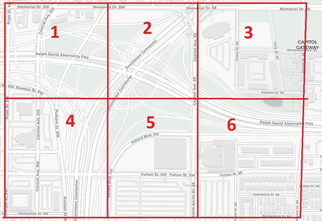
This is a map of the interchange just south of downtown Atlanta. Today, it’s where the Downtown Connector (I-75 and I-85) and I-20 meet … But what was here before the highways?

Look at the drop-down list for “Highway Interchange Excavation” to see what GSU students discovered about the history of this erased section of Atlanta.

Downtown ATL’s history hides in plain sight

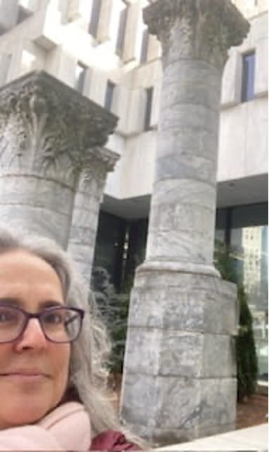
The big concrete plaza in front of 25 Park Place is kind of blah, but every once in a while I stop there to admire the marble columns in front of the building. They remind me that so many of Atlanta’s beautiful old structures have been destroyed and replaced by modern architecture. But I think it’s kind of sly that someone kept these pieces here, so we might ponder them. What were they? Why are they there now?

Dr. Davis in front of the Equitable columns at 25 Park Place NE
Dr. Davis and the columns

These three marble columns (and the façade behind it, inside the GSU Career Services center) were once part of the Equitable building, which stood where GSU’s CMII building is now. When it was built in 1892, it was the tallest skyscraper in the city (eight stories — back then that was a really tall building). It was originally known as the Trust Company of Georgia building.

When the building was demolished in 1971, its eighteen columns were scattered around the city. I have no idea why these three are here today, or how the building’s arched entrance came to be preserved and installed inside. Maybe the SunTrust Banks did it, when they owned this building?

However they got here, I’m always glad to notice these lovely pieces of craftsmanship. It feels like some weird random piece of old Atlanta has been plopped down on a barren and characterless public urban plaza. I dig the juxtaposition.

Skip to toolbar