Growing up in repressive rural Georgia hours north of Atlanta, I dreamt of going to Pride in Piedmont Park – a chance to experience freedom, joy, hope, and love in the expression of the queer identity. Now at college and in my third year in the city, I am a few months out from attending my third Atlanta Pride. It has been everything I hoped: the colors, smiles, excitement, compliments, free mom hugs, drag queens swinging from poles on moving floats, seeing old friends, making new connections, and overwhelming emotion at the scale of LGBTQIA+ representation. Pride at Piedmont Park and the larger community provides the most electrifying, knowing, and supportive environment where one can see those both alike and different. Every year the smaller-than-you’d-think community gathers bumping into exes and impending self-realization yet are happy in the light air of the large gathering of a normally stigmatized and disjointed community. Experiencing this I found myself curious as to how such a setting, and Atlanta Pride, were born – what people, places, and ideals coalesced to create the resonant gay culture that midtown has become known for?
Continue readingthe histories of our streets
Georgia State University students map Atlanta's past
Month: April 2024 (page 1 of 2)
Some people may look at the space now and see the Mercedes Benz, and fondly remember the Georgia dome. However , many individuals don’t know what used to lie in its place and how the dome’s costly development and how it affected the lives of those around it.


Atlanta historically served as a connection for railroads and since then has economically boomed. In 1835, the state of Georgia was determined to build a railway to the Northwest, from the Tennessee line to the southwestern bank of the Chattahoochee River, and through Athens, Madison, Milledgeville, Forsyth, and Columbus.3 Eventually, Atlanta became the center for the South. With the consistent growth in population, Atlanta has rapidly developed and evolve from the Civil War to the 1996 Olympics, the existence of the Underground became a result of this.4 The shopping and entertainment district in the heart of downtown Atlanta, also known as “the city beneath the city”, holds rich history and culture. Today it stretches across 50 Upper Alabama St SW which was historically constructed along the zero-mile post sometime during the 1920s.
Continue reading
As a first-generation Mexican-American, Plaza Fiesta is a place with fond memories. The plaza was one of the rare places where I felt that I fit in, away from the stares of others. I grew up in a majority-white community in Cherokee County, Woodstock. So, getting to experience places like Plaza Fiesta occasionally was very refreshing for me and my family. Here, we didn’t have to worry about our English proficiency. Instead, we didn’t need English at all. My father got to ask all his silly questions without me having to translate them, and my mother got to feel a little less homesick. Granted, this is only one of many small spaces along Buford Highway that give Mexican families a sense of familiarity. However, Plaza Fiesta is different because it is the only market designed for Hispanic communities to spend their day like they would in their countries.
Looking at this lot’s history, we can see the evolution of Buford Highway and its demographic change. We will also see that the lot has always been geared towards the community in the area. This lot, along with many other spaces in the corridor, shows the adaptability and openness to new business regardless of race.
Continue reading
Western Facade of the Capital Blueprints1
If you were to think of the Georgia State Capitol, the image that would come to your mind would likely be the imposing building sitting just south of the Georgia State University MARTA station. Standing atop Capitol Square Block, the structure gated off from the outside. Several statues adorn the outside along with maintained lawns to give an almost park like appearance. The actual structure itself is four stories tall with four asystematical facades that adorn its outside. Its main entrance, the west main entrance, is the grandest of these facades. Carved into the stone above the west entrance in a relief carving are four figures and the seal of Georgia. On the right of the seal is a man and a woman. The man represents the armed forces with a helmet and sword and the woman represents peace with her horn of plenty. On the left side, there is another man and woman. The woman holds mercury and an anchor to symbolize trade while the man holds a hammer to symbolize industry. Yet, towering above the four figures is a fifth. Standing atop the capitol building at its highest point, standing on a dome of gold, is a robed women holding a sword and a torch representing the idea of liberty.
Continue reading
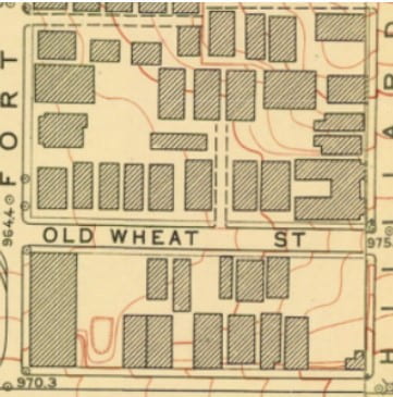
Right on Auburn Avenue and Hillard street stands the Prince Hall Masonic Temple, a building that is a token of the historical Sweet Auburn passage. Before its pivotal role in history, the lot which now hosts the building, was vacant for a period of time, then a duplex was built on the vacant land, as indicated by historical maps.
Continue reading
John Portman
John Portman was born on December 4, 1924, in South Carolina. Portman was raised in Atlanta and served during World War II. He attended Georgia Tech where he would study and earn his degree in architecture in 1950. He opened his architectural firm in 1953 and named it John Portman and Associates. This company would transform his company into a real-estate company, and eventually become involved in a home decor wholesaler. Not only would his work be in the city of Atlanta, but also in Chicago, Illinois; California, San Francisco; and Detroit, Michigan. Portman would become an important architect and restate developer figure in Atlanta’s development of Peachtree Center and reviving the decaying city. 1
Continue reading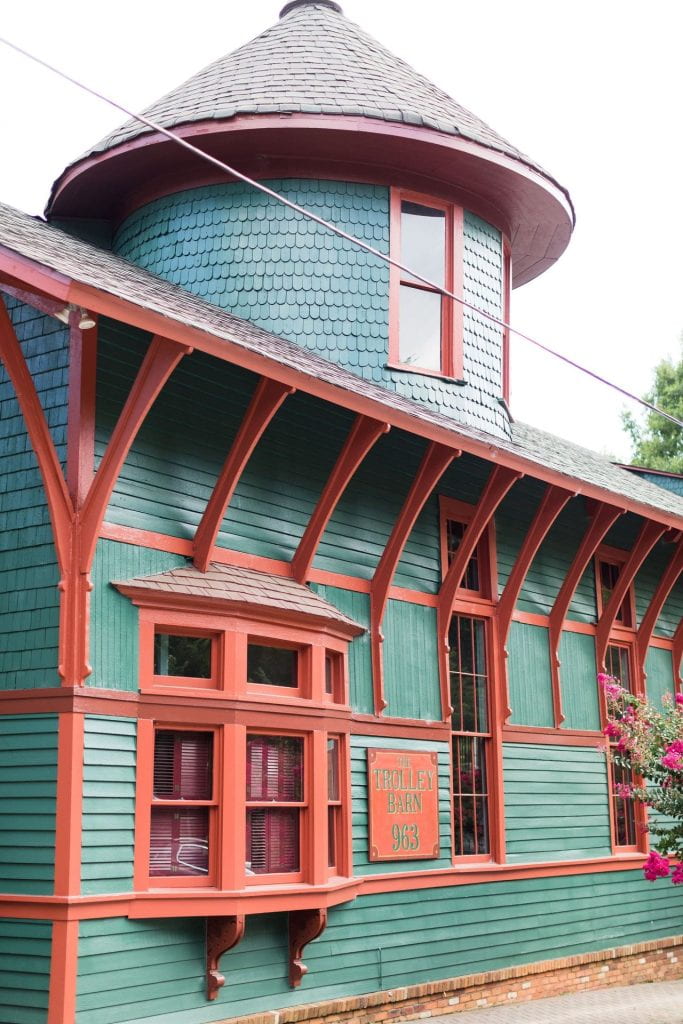
If you travel down Edgewood Avenue, you’ll pass through historic parts of Atlanta that have a deep and rich history with the city of Atlanta, including through the retail district and into the historic Inman Park neighborhood. This rich history extends throughout Edgewood Avenue, however there is one building which tends to stand out near the east end of Edgewood Avenue, near the Inman Park/Reynoldstown MARTA station — the Trolley Barn.

The Winecoff Hotel, currently known as the Ellis Hotel, was burned down on the early morning of December 7, 1946. The fire started around 3:15 A.M. and claimed the lives of 119 occupants. 1The story of large building fires during the 1940s was not a unique one, but the Winecoff Hotel Fire created a wake up call for fire safety throughout the country. The absence of fire alarms and sprinkler systems in the Winecoff Hotel resulted in an update to building codes around the country. Eerie stories of abnormal activities at the current Ellis Hotel has been a catalyst for a local Atlanta bone-chilling chronicle.
Continue reading
Centennial Olympic Park is the centerpiece of Downtown Atlanta, where tourists and locals alike can unwind in the grass, take a stroll through the various Olympic monuments and look at breathtaking views of Downtown’s skyline. As a kid growing up in Atlanta, I always loved the design and location of this park, nestled in the center of a bustling city. I remember always having a blast running through those Olympic rings. But before this urban centerpiece was even a park, there is an interesting history of what was there before.


Hurt Park is a two-acre park located at 25 Courtland St SE. Opening in 1940, the park transformed “an area of rambling, obsolete and run-down structures into a rolling stretch of green lawns.”1 Named after Joel Hurt, one of the most influential people in the city’s early history, the park is now co-owned by the City of Atlanta and Georgia State University after a recent renewal. But what was the history behind the land and the man it was named after?
Continue reading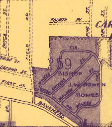
Bowen Homes was an Atlanta Public Housing development built in 1964. It was one of the last developments that was demolished in 2009. What was once one of Atlanta’s largest housing developments is now 74 acres of vacant land with only the abandoned A.D. Williams Elementary school left standing. Plans for redevelopment have been announced but work has yet to begin.
Continue reading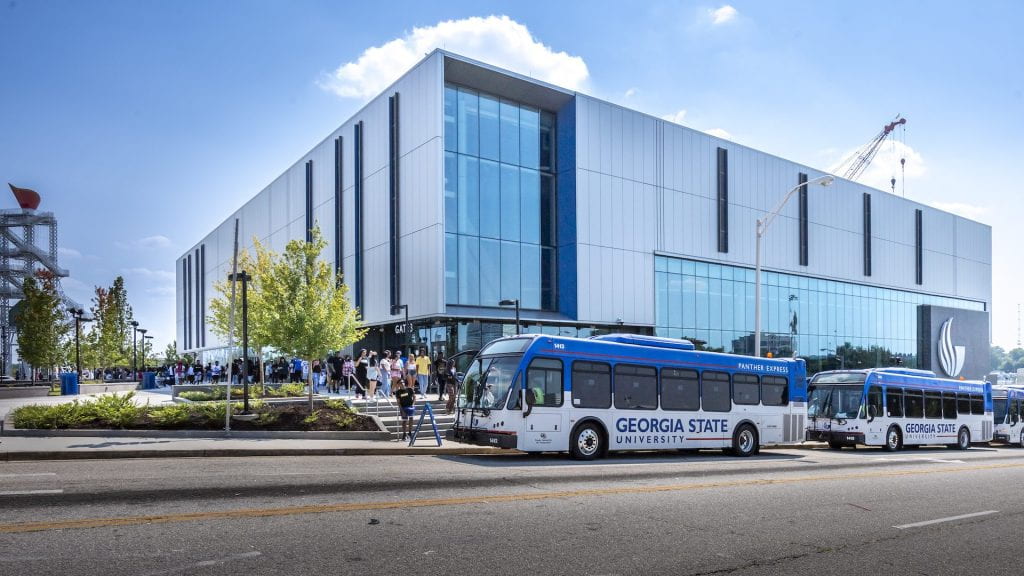
In 2020 contractor Brassfield & Gorrie broke ground to build Georgia State University’s Convocation Center.2 This premier facility has already been incorporated into GSU’s operations, hosting athletics and graduation ceremonies, among many other events. Occupying an entire block across from GSU’s Blue Lot, its presence looms large in Summerhill. The center has yet to see a class from freshman convocation through commencement, and this newness raises a question: how did GSU acquire the land, and what was there before?
Continue readingThe Immaculate Conception Convent was located at 235 Washington Street. The Convent was part of the Catholic church and represented an area of religious work. Before the expressway was built, the building existed right underneath where the express lies today. An entire community existed underneath the expressway which included apartments, houses, and even a vocational school. The disappearance of this area was caused during the building of the expressway but there is evidence that suggests that an entire community existed before.

The Immaculate Conception convent was located near many duplexes and in front of the Vocational school. The convent seemed to be a celebrated location in the community as it provided religious services. The Convent represented the catholic church that housed nuns, provided church school, and was mainly dominated by women. The Convent also was referenced in the Atlanta Constitution Newspaper multiple times. The convent seems to be mostly forgotten and erased from Atlanta’s history, but there is limited evidence that proves that this convent once served a community.
The Atlanta Constitution provided newspapers that gave a glimpse of how the convent served the community. An article that was written on June 20, 1891, simply promoted church exercises and mentioned how the services were done mainly by women.1 The promotion’s purpose was to encourage people to show up and attend mass in the evening. On July 5, 1935, the Atlanta Constitution covered the 50 anniversary of Sister Mary Loretta Hogan and her service to the Immaculate Conception Convent.2 The newspaper mentioned how she served as a teacher, nun, and nurse in the convent. Another article that referenced the convent was written on Oct 3, 1937, which covered the celebration of the 60th-anniversary career of Sister M. Elizabeth Donelan.3 The newspaper dedicated a page that covers the sister’s biography and her service to the convent in Atlanta. The articles prove that women dominated the building and that there once existed a convent which was replaced by concrete expressways.

The Fulton Vocational School was located next to the Immaculate Conception Convent and near the Fulton High School. A Vocational school is a trade school that provides programs on multiple careers including electricians or carpenters. The Fulton Vocational School was purposely located near the Fulton High School in order to encourage students to seek technical careers. The Atlanta Constitution barely gives any references to this vocational school, but there is coverage that mentions Fulton County’s attempt to create programs to create jobs. One interesting discovery was that Fulton County was creating these vocational programs to discourage crime and help male students become mechanics, plumbers, electricians, or printing skills.4 A newspaper that was published on August 10, 1957, announced the construction of the expressway that was forcing the community to be moved near Cleveland Ave, near the prison.5 This coverage mentioned how the community was going to be re-established in a new community and would cost about $350,000 to do so. 6

Today, both the convent and vocational school are gone from existence. The only traces of these buildings were poorly recorded in the newspaper and apparent in the Atlanta 1932 Sanborn Map. The area in which these buildings were located has fallen to the expressway.
Citations:
- “THE CLOSING EXERCISES: OF THE IMMACULATE CONCEPTION CONVENT LAST NIGHT.” The Atlanta Constitution (1881-1945), Jun 20, 1891. https://www.proquest.com/historical-newspapers/closing-exercises/docview/193688538/se-2. ↩︎
- “Catholic Teacher Marks Fiftieth Anniversary.” The Atlanta Constitution (1881-1945), Jul 05, 1935. https://www.proquest.com/historical-newspapers/catholic-teacher-marks-fiftieth-anniversary/docview/502277590/se-2. ↩︎
- Land, Maxine. “Sister Marks Her Diamond Jubilee in Celebration at Convent here: 81-Year-Old Nun Attributes Membership in Order to Arrival of Sister in Family; Friends Honor Her Career Sister Marks 60th Anniversary in Convent.” The Atlanta Constitution (1881-1945), Oct 03, 1937. https://www.proquest.com/historical-newspapers/sister-marks-her-diamond-jubilee-celebration-at/docview/502998531/se-2. ↩︎
- FULTON PLANNING SCHOOL OF TRADE, PLACEMENT BUREAU: CENSUS WILL BE TAKEN TO FIND WHAT OCCUPATIONS LACK TRAINED WORKERS URGES CHILD TRAINING. (1938, Jan 23). The Atlanta Constitution (1881-1945) Retrieved from https://www.proquest.com/historical-newspapers/fulton-planning-school-trade-placement-bureau/docview/503158200/se-2
↩︎ - “Fulton Office Giving Way to Freeway.” The Atlanta Constitution (1946-1984), Aug 10, 1957. https://www.proquest.com/historical-newspapers/fulton-office-giving-way-freeway/docview/1611985467/se-2. ↩︎
- “Fulton Office Giving Way to Freeway.” The Atlanta Constitution (1946-1984), Aug 10, 1957. https://www.proquest.com/historical-newspapers/fulton-office-giving-way-freeway/docview/1611985467/se-2.
↩︎
The area of Summerhill between Capitol Avenue and Woodward Avenue was mostly residential homes and apartments. However, one building that stands out is the Jewish Educational Alliance that was built in 1911. This building was meant to serve the community and a place where everyone could gather. Most of the residents in the area were Jewish, so they could go to services on Sunday and also bring their kids to kindergarten there as well. The facility also had a gymnasium (presumably for the daycare/kindergarten) and an on-site health facility that would also serve residents.
Continue readingAs has been alluded to in other posts, this area thrived as a predominately Jewish community throughout the early 1900s, with waves of immigration from Eastern European Jews. Several Jewish Synagogues and Congregations could be found in this area. Some of the most notable Jewish congregations in this area included the Beth Israel Synagogue and the Hebrew Benevolent Congregation. However, over time, this Jewish community largely began to dissipate and move to other parts of Atlanta. Many of the Congregations and Synagogues either moved or closed down, and were replaced largely by Christian ones.

Further into the 1900s, we begin to see more and more of these Christian Congregations and Churches popping up throughout the area in the city directories, and a notable increase in the number of standalone shops and apartments. Several of the older Jewish synagogues and congregations in the area were either replaced by Christian congregations as the Jewish population moved out, or they were bulldozed and turned into Apartments.
By the time we reach the 1950s, much of the area consisted of Apartment complexes, including ones which were largely vacant throughout their existence. Many of the original homes also stood, but this notable increase in Apartments is significant in pointing out how the exodus of the Jewish community began changing the landscape of the area.
We also begin to see the City of Atlanta start making notable considerations in how they want to plan the interstate highways towards the middle of the century. In 1945, the City of Atlanta released an Urban Land Usage map that showed much of this area as largely residential with a few commercial buildings dotted throughout the area. However, much of this residential area was deemed as substandard. This designation likely reflected much of the changing demographics of the area and a negative attitude towards the racial makeup of the area, or simply reflected the fact that many of these homes were, at the time, fairly old in comparison to some of the newer neighborhoods in Atlanta. Either way, this designation likely ended up playing a large role in determining where the highways would intersect and bulldoze their way through the landscape.


By the time we reach the 1960s, and once the interstates have already razed much of these neighborhoods, we can see how they were used to create a dividing barrier between communities. In a 1962 Negro Residential map, we can see colored areas representing the areas populated by “Colored” races, and the non-colored areas populated by white people.
Fast forwarding to today, this area does not reflect much of its past. Many of the lots are vacant or empty, and a lot of the area consists of parking lots and parks developed in urban renewal efforts that served to replace the already-gutted community in this area. There are very few symbols of the significance that this area once had for Atlanta’s Jewish Community, or the people that lived here.
- Sanborn Fire Insurance Map from Atlanta, Fulton County, Georgia. Sanborn Map Company, Vol. 4, 1911. Map. https://digitalsanbornmaps-proquest-com.eu1.proxy.openathens.net/browse_maps/11/1377/6154/6520/97571?accountid=11226 ↩︎
- Atlanta City Directory Company. (1953) ↩︎
- Map of Atlanta: Negro Residential Areas 1962, Planning Atlanta City Planning Maps Collection, Georgia State University Library. ↩︎
If you were to leave the Georgia State Campus going south, you pass on by the Georgia State capital before going over a bridge across I-75 and I-85. What will greet you is a concrete wasteland, filled with rusted idols dedicated to the past glories of the Olympics. While you may be tempted to quickly rush your way on further south to the rapidly gentrifying Summerhill, you may want to walk through the empty parking lots and wonder what came before.
The parking lot south of the convention center did not used to be an empty concrete scar across the Earth. Rather, its history whispers of a bevy of different inhabitants that called this empty lot home. Today we will examine the development of a forgotten block of homes, that lay between Richardson Street, Fulton Street, and Crew Street.
Continue reading

The Downtown Connector runs through the heart of Atlanta, conceived during the transformative period of the city. The ambitious project of the connector connects the northern and southern suburbs outside of Atlanta giving into the car culture that was flourishing within the city. Before its construction, residents and businesses lie where there are now strips of interstates. Looking at an illustrative view of a 1911 map, where north was Fair Street (now memorial Drive), East is Capital Avenue, South being Clarke Street, and West was Washington Street we notice how the space’s landscape consisted of residences and commercial establishments.


In the upper north part of the downtown connector lies Woodward Avenue. Before the 1920s, the northern segment of Woodward Avenue, lying beside Capitol Avenue boasted a rich community life including an old sanatorium (which is another name for hospital) with surrounding duplexes and a church called Christian & Missionary Alliance Chapel. Based on old city directories, Woodward Avenue consisted of white residents until the gradual influx of Black individuals came and integrated themselves into the community which changed the foundation and became a main target of the renewal plan that has yet to come.


In the late 1800s, ambitious Christians wanted to provide education to kids, particularly in literacy. This process eventually becomes a Sunday school which evolves into a church called the Fifth Baptist church. The church was established with a mission to serve and uplift the community. This church lies in the space of where the old Christian & Missionary Alliance Chapel used to be. As mentioned earlier there was a growing population of black individuals in the area which impacted the church leaders’ attitude towards a mixing community. This caused the church to sell its property and move to the Grant Park area. The church then decided to rename themselves Woodward Avenue Baptist Church. The church was then displaced later on with the construction of I-20. The story of the Woodward Avenue Baptist church reflects the dynamic between faith, community, and urban development in Atlanta’s history. Its humble beginnings soon shifted due to race changes and a shift in the city social landscape.

In a 1932 sandburn map, lies a noticeable absence which was once home to a couple of churches now lying vacant. Comparing this picture to old maps still shows the area being congested with apartments and businesses. What was known as the sanatorium in an older map in the area now has a name called Atlanta Hospital. What was really surprising was that the hospital chose to turn the apartment building next to it into a nurse’s home with a tennis court sitting behind it. This choice speaks to the hospital commitment to provide medical services and support the comfort of their staff. Right next to it was housing for displaced girls called Eliza Magnet Home for Girls. These elements of this urban environment paint a vivid picture of institutions and communities addressing the needs and challenges of that time.
The Downtown connector signifies the city’s evolution and adaptation amidst a shifting culture. Born during a period of culture, it transformed the urban fabric which replaced residential and commercial space with interstate highways. Memories of Woodward Avenue may fade against the background of urban renewal, but it illustrated the intricate relationship between institutions and communities to evolving needs.
Resources
Sanborn, D.A., “Atlanta 1931-1932 vol. 3, 1932, Sheet 312,” ProQuest, (ProQuest Digital Sanborn Maps ~ Map of Atlanta 1931-1932 vol. 3, 1932, Sheet 312 (openathens.net) accessed March 8, 2024).
Atlanta City Directory Company. (1970, January 1). Atlanta City Directory Co.’s Greater Atlanta (Georgia) city directory … including Avondale, Buckhead … and all immediate suburbs .. : Free download, Borrow, and streaming. (Atlanta City Directory Co.’s Greater Atlanta (Georgia) city directory … including Avondale, Buckhead … and all immediate suburbs .. : Free Download, Borrow, and Streaming : Internet Archive : accessed March 8, 2024).
History. Park Ave Baptist. (n.d.). (History | Park Ave Baptist: accessed March 8, 2024).
Explore. ATLMaps. (n.d.). (Explore: ATLMaps: accessed March 8, 2024).
Washington_rawson_1911.jpg (4467×9985) (wikimedia.org)
Subscribe by Email
Completely spam free, opt out any time.
This form is protected by reCAPTCHA and the Google Privacy Policy and Terms of Service apply.

© 2024 the histories of our streets
Theme by Anders Noren — Up ↑