Annotated Bibliography 2

Roy, Parama. “Collaborative Planning – A Neoliberal Strategy? A Study Of The Atlanta Beltline.” Cities 43.(2015): 59-68. ScienceDirect. Web. 5 Feb. 2016.

Written by a Geo-sciences professor at Georgia State University, the article’s purpose is to assess the Atlanta BeltLine planning project. It will discuss the implications of the collaborative planning theory used for the BeltLine. It will also talk about how the collaborative planning theory could have been corrupted by market-driven decisions. The author proposes that market-driven decisions ruin the democratic process of planning. The example given is decisions regarding the historic Old Forth Ward neighborhood in Atlanta. This article will helpful to my research because it will give specific examples of the decisions for the BeltLine and how it changed historically African American neighborhoods like Old Fourth Ward. It will further show corruption amongst the decision makers. This article isn’t a primary source; therefore, the arguments proposed could be false. What if the decisions weren’t market-driven? What if the author missed something important? What if they used information that would  only support their thesis? These questions must be taken in consideration when using this source; however it is still an great source because the argument given is understandable based on the grounds given.

Annotated Bibliography 1

Holliman, Irene V. “From Crackertown To Model City? Urban Renewal And Community Building In Atlanta, 1963-1966.” Journal Of Urban History 35.3 (2009): 369. Publisher Provided Full Text Searching File. Web. 5 Feb. 2016.

This article, written by a historian at the University of Georgia, studies the mayor, business men, organizations, and residents in Atlanta during the 1960’s during the urban renewal phase. There are two sides to the issue. Some wanted the money for public housing and others thought it should be spent to protect the property values of business districts. The problems arise because of site selections, limited funding, and planning. This article will further my research because it will provide information about the planning aspect of the urban planning time period of Atlanta. This source is the correct time period and place for my research. I will receive more details about the people’s resistance to the new plans and their plans to keep their homes. The article is not a primary source. Just like myself, the author of this article had to conduct research. The article could miss some information that could be useful; however, it is still relatively important because it will give informative insight on the city councils and business associates reactions to the troubles placed upon them. It will also show what precautions the public took to keep their neighborhoods from being torn apart.

Annotated Bibliography 3

Hyra, Derek. “The Back-To-The-City Movement: Neighbourhood Redevelopment And Processes Of Political And Cultural Displacement.” Urban Studies (Sage Publications, Ltd.) 52.10 (2015): 1753. Publisher Provided Full Text Searching File. Web. 5 Feb. 2016.

This article was written by an associate professor at Virginia Tech. It talks about a study that assess the population influx of citizens in Washington D.C between 2009 and 2012. The concentration is solely on the redevelopment of the Shaw/U Street neighborhood, which is known to be an African American neighborhood. A population increase has forced residents out and new ones to accommodate them, making property values to increase. This is what the author calls “The Back-To-The-City Movement”. The effects of this movement is discussed and demonstrated in specific examples. I chose to use this source because it will give information about the effects of redevelopment of an existing neighborhood. It’s even more beneficial because the district being discussed is an African American neighborhood; which is highly relevant to the topic. The article is in the right time period; however the place in question could be a problem. My research is about Atlanta’s redevelopment. Although, the article studies a different place, it is still great to use because the information can be used to compare the effects of Atlanta’s redevelopment with another major city; thereby, showing it’s not just Atlanta’s issue but can be any city’s issue.

Unknown Phenomena of Atlanta: The Jackson Street Bridge

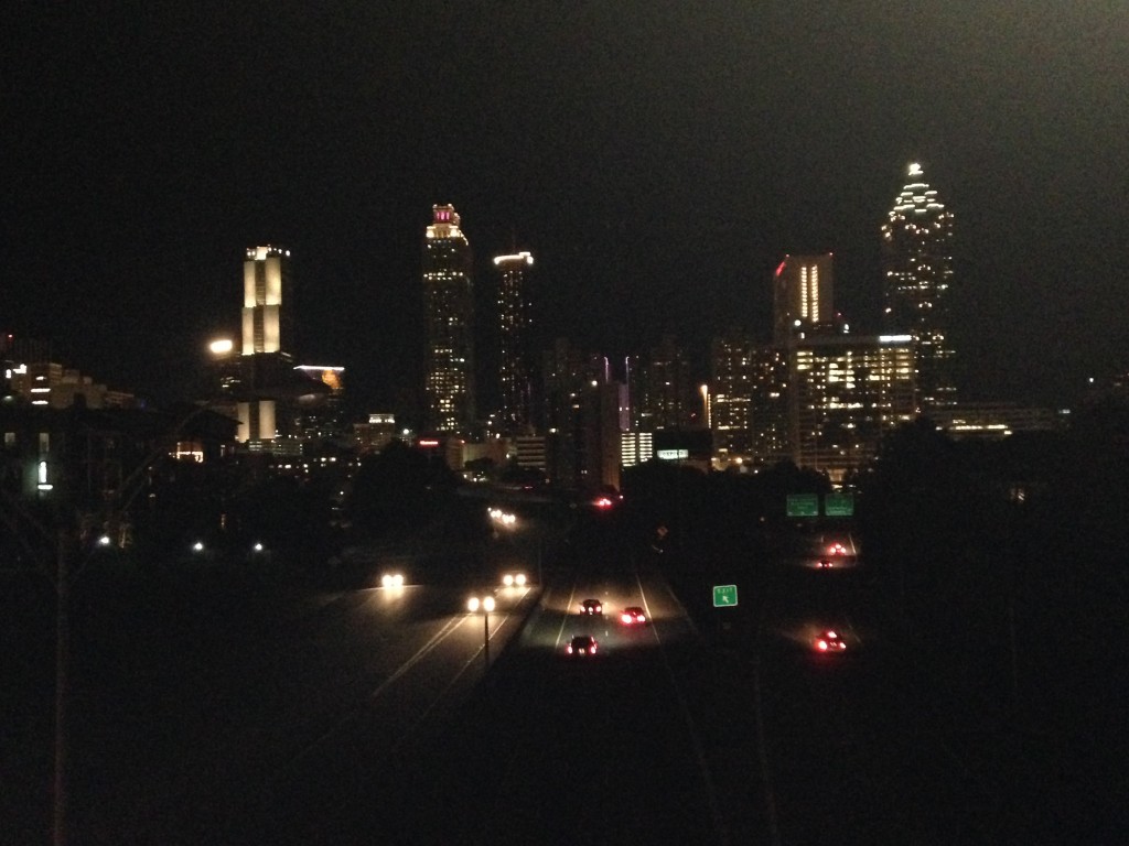
Atlanta Skyline

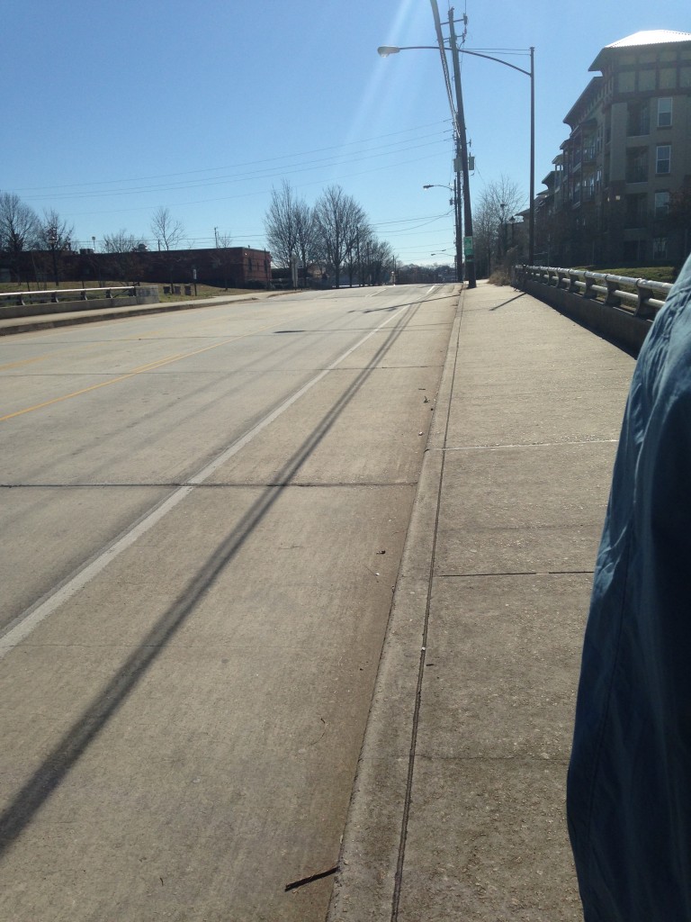
The “picturesque” view from the Jackson Street Bridge is something that most people don’t recognize on the internet or on television. It is the unknown phenomena; the view that has seen so many faces but the faces hasn’t seen it. The bridge is considered the best place for anyone to get an eye-full of Atlanta without spending a penny. In relation to places, the bridge is between the Martin Luther King Jr. Historic Site and Atlanta’s Medical Center. The bridge is right above Interstate 75, looking right ahead to the inner connection of highways in Atlanta or the Freedom Parkway.
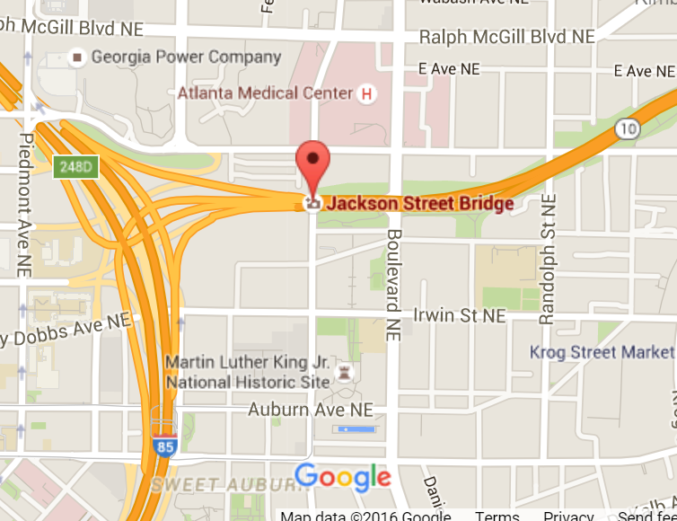
Location of the Bridge

Location of the Bridge

The history behind this 50+ year old bridge is that it was fought for by the people. The implications of the Federal-Aid Highway Act of 1956 lead to mass deconstruction of urban housing. In Georgia, the Department of Transportation planned to have Interstate 75 run right through some historically African American neighborhoods like Old Fourth Ward and Sweet Auburn. Many people were pushed out of their homes but those that stayed fought for justice in court. The ending compromise resulted in the construction of this very bridge. They didn’t realize that they were going to create an amazing hotspot for future residents and tourists to enjoy.

It’s an easy place to access once you realize where it is. Riding a bike there works too because a bike lane is provided which is quite convenient. There are houses and apartments on each side of the highway. The opposite side of the bridge has houses and parts of the Martin Luther King Historic site. Most people who stop here are photographers, local residents, and tourists coming to take selfies with the Atlanta Skyline. Many people have been seen walking their dogs across the bridge to get to the park provided by the MLK historic site.

The first time you may visit this place might seem intimidating and mesmerizing however the bridge level and rail is pretty low. It’s not a good idea to stand close or lean over the bridge while looking at the view because you could tip over! The feeling of cars rushing under you makes you want to look over the bridge but don’t. When taking pictures, be mindful of where you stand! The sounds you might hear depends on the time of day. Interstate 75 is quite busy throughout the day so you will hear tons of car horns and traffic. The colors seen during the day are green and blue. The blue comes from the sky; hugging the buildings, while the green come from the grass surrounding the highway.

In contrast, during the evening, the sounds are very serene and discreet. You will hear quite a few cars driving by but nothing too loud. The colors become black. There are only a few lit places on the highway and bridge because of streetlights. The lights in the different buildings faraway look like millions of stars in the sky. Because of the view and vibe at night, it is considered to be a romantic places. Couples tend to display their love on this bridge and often leave something behind.

Sources used to assist –

Corson, Pete. “Golden Hour at the Jackson Street Bridge.” MyAJC.com. Atlanta Journal Constitution, 13 Feb. 2015. Web. 2 Feb. 2016.

Dominey, Todd. “Atlanta’s Jackson Street Bridge.” Todd Dominey. Todd Dominey, 9 June 2014. Web. 02 Feb. 2016.

Jackson Street Bridge, Jackson Street Bridge. Personal photograph by author. 2016.

How do I use Zotero?

I’m not following the program quite well. I’m not even sure what the program is for. Do I search sources on this website? It is there to just give me a format?

This entry was posted on February 1, 2016, in SOS. 1 Comment

Summary #2 Tapestry Of Space: Domestic Architecture And Underground Communities In Margaret Morton’s Photography Of A Forgotten New York

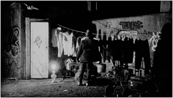
Gallery of Morton’s Pictures

The article, Tapestry of Space: Domestic Architecture and Underground Communities in Margaret Morton’s Photography of a Forgotten New York, written by Irina Nersessova talks about Margaret Morton’s photographs of New York’s homeless populations’ home life and it’s parallel with the life of someone who is housed. Morton’s photographs captures the everyday life of the displaced in New York. According to Nersessova, homelessness is as nothing different as someone who is housed. Morton’s pictures depicted that the homeless have a home. The only difference between the housed and the homeless is the level of stability of their home.
In reference to Morton’s photographs, the homeless use their space as a creative guide just like a homeowner would. The decoration acts as an indicator that the space is theirs. An example would be that a homeowner might name their home with their last name. The same goes for a homeless person who puts their name above their space. Unlike a homeowner, the homeless will use material scraps that they find whereas a homeowner can go out and purchase letters to put on a mailbox or a fence that will be placed in front of the entrance. Nersessova goes on to say that “…the displaced best represent the universal relationship between space and the splintered identity.”
Ideally, a home is a place where you often feel safe. A homeowner will feel safe in their home because it isn’t likely that an unwanted guest will intrude. Even more, it can act as a refuge to get away from the outside world. This idea can apply to a homeless person as well. The public are usually unfamiliar with a developed homeless society like New York’s tunnel. Consequently, they will ultimately end up ignoring them, making the place perfect protection from the outside world. The only difference is that the homeless have definite security; it’s a paradox, because a place so open, compared to a house, should be less safe. However, as Nersessova explains, “The absolute darkness of the tunnel prevents danger from entering it, which explains how it is possible to have the highest feeling of safety in a place that is perceived as most dangerous.”
Most often, people will think that the homeless are undesirable that don’t contribute to society; however, they are mistaken. The displaced persons in Morton’s pictures, live in the world of mass production and capitalism just as housed people do. The only difference is how their contribution has an effect on their psychological attitude. A homeowner contributes by maybe owning a business or purchasing products from a privately owned business. Nersessova goes on to describe how consumerism can consume a person, forcing them to demand for excess. A homeless person contributes by using the thrown-away products by the product-obsessed population. Some may use those products to keep them warm, to decorate their space, or help them make a little change in order to buy supplies they may need. Nersessova voices how their mentality can’t be reduced to commercialism due to their lack of resources.
As described above, the homeless life isn’t that much different from the ones whose home is more stable. A homeless person’s space can feel just as safe as a house to a homeowner, if not more. A homeless person can definitely decorate their space to indicate ownership just as a land owner can. In addition, a homeless person’s contribution is very much desired in society as a homeowners does, even if society; itself, doesn’t realize it. Furthermore, the parallels between the housed and the homeless demonstrated in Morton’s photographs aren’t very noticeable at first but as Nersessova breaks down those misconceptions in this article, a reader can begin to visualize Morton’s purpose.

NERSESSOVA, IRINA. “Tapestry Of Space: Domestic Architecture And Underground Communities In Margaret Morton’s Photography Of A Forgotten New York.” Disclosure 23 (2014): 26. Advanced Placement Source. Web. 26 Jan. 2016.

Summary #1 Architectural Exclusion: Discrimination And Segregation Through Physical Design Of The Built Environment

Sarah Schindler is determined to inform and evaluate the idea of architectural regulation of urban areas in her article, “Architectural Exclusion: Discrimination and Segregation through Physical Design of the Built Environment.” She describes architectural regulation as an unrecognizable threat to socioeconomic and racial exclusions from certain areas. She explores how this idea is overlooked by lawmakers and the courts. In the process of explanation, she also provides excellent examples. As stated by Schindler, “Exclusion through architecture should be subject to scrutiny that is equal to that afforded to other methods of exclusion by law.”
Her main reason for why lawmakers aren’t discontinuing this issue is because they fail to see the effect of many architectural elements in city projects. Although, not all legal scholars are blind to this issue, they misinterpret it as a metaphor to build on the idea of hidden regulatory systems. Schindler; however, insist that it isn’t just a metaphor; but, in actuality, a real regulation as well. According to Schindler, regulation through architecture is powerful but is also less indefinable, making it harder for legislators and common people to roar for a change. Most architectural things about places are seen as
An example she describes is a physical barrier like fence or bridge. She discusses how a ten-foot high, 1,500 feet long fence separates the suburb of Hamden, Connecticut and the housing projects in New Haven. The divider makes it difficult for people living in the projects to have access to the outside community. A trip to the grocery store made housing residents “…have to travel into New Haven to get around the fence, a 7.7-mile trip that takes two buses and up to two hours to complete.” The common reason for construction of the fence was primarily to keep violence out however, the underlying intention was to keep undesired people, like poor citizens or people of color, from having access to the surrounding city.
Another example is the placement of public transportation. She reminds us that most low income citizens rely heavily on public transportation whereas wealthier citizens have private automobiles. Some places like the mall refuse to have transit stops because they don’t want a certain kind of people having access to that location. Therefore, the only people being denied access are the lower socioeconomic class. She also brings up the point that this issue can have a larger impact because then it makes it problematic for those people to have jobs in those areas. This would mean that employers would have to pay a higher wage because citizens of that community are not likely to accept a job with minimum wage as a low income citizen would. She even states that even if the lower- income citizen did have a car, some communities require a parking permit. If that person did not live there or didn’t know a friend who could offer a guest pass, they would be out of luck; making their trip even more hectic.
Schindler continues to say that legal decision makers can’t recognize this problem and address it. They are too busy paying attention to what the courts consider to be physical exclusion instead of conducting their own research. This isn’t to say that they are totally blind to the idea. They have shut down or put limitations on cities’ attempts to practice racial zoning, exclusionary zoning, and racially restrictive covenants. However, architecture is unlikely to be seen as a way to keep someone out because it isn’t as obvious as a law. To a common pedestrian, the different features about a place is just that; a feature.
In conclusion, Schindler offers solutions that can be made in the judicial process however; doesn’t believe it will do much good. She mostly recommends “forcing reformation of certain existing discriminatory infrastructure…” in the legislative process.

Just a regular bench

               Just a regular bench

To anybody else this will just seem like a regular bench, however that person is sadly mistaken. What if the designer made it this way so that a homeless person couldn’t sleep comfortably on it? What if it was only to limit how many people could sit on the bench? These are the types of questions that won’t be asked by a regular pedestrian.

SCHINDLER, SARAH. “Architectural Exclusion: Discrimination And Segregation Through Physical Design Of The Built Environment.” Yale Law Journal 124.6 (2015): 1934-2024. Academic Search Complete. Web. 26 Dec. 2016.

Hello world!

Welcome to your brand new blog at sites@gsu.edu!

To get started, edit or delete this post and check out all the other options available to you.

For assistance, visit the comprehensive support site, check out the Edublogs User Guide guide or stop by The Edublogs Forums to chat with other edubloggers.

For personal support, you can attend Georgia State’s training on Edublogs or stop by The Exchange for one-on-one support.

You can also reference the free publication, The Edublogger, which is jammed with helpful tips, ideas and more.