
This is a picture of a package of cookies offered at the farmers market. These are not sold at common grocery stores and are advertised in Spanish, catering to the Hispanic customers.

This is a picture of a package of cookies offered at the farmers market. These are not sold at common grocery stores and are advertised in Spanish, catering to the Hispanic customers.
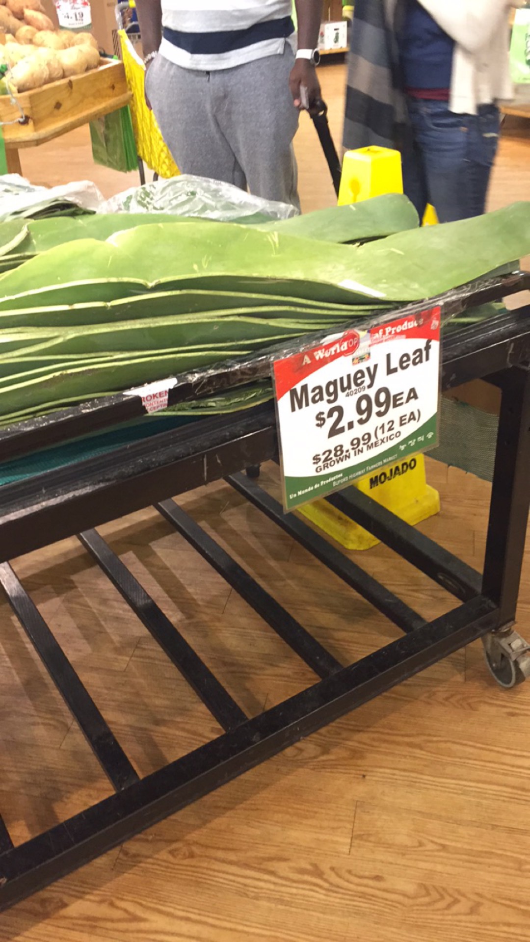
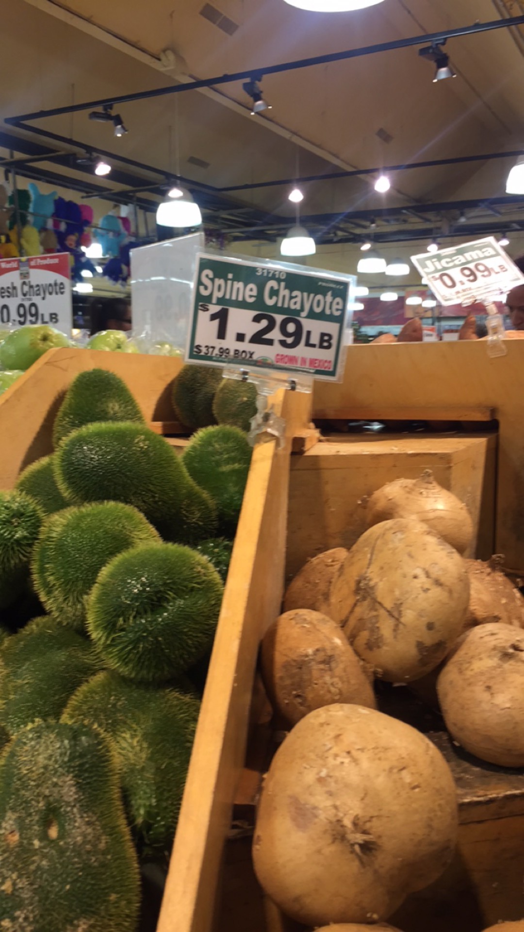 Pictured here are three types of products offered for sale at the Buford Highway Farmers Market. These products would not be found at other common grocery stores such as Publix or Kroger. These products have bright colors and have spiky, smooth, or rough feeling textures.

This is an image of the flowers offered for sale at the Buford Highway Farmers Market. The market has displayed the flowers using nice unique pots, unlike the generic plastic ones used at other grocery stores.
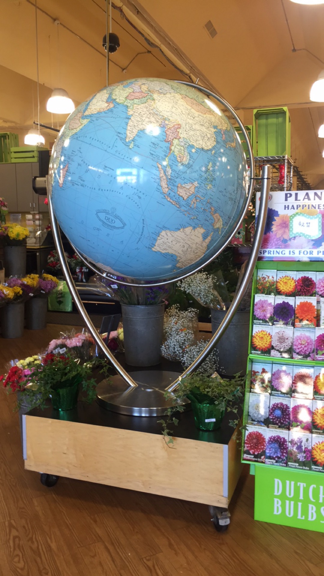
This is a picture of what you see immediately after stepping into the market. It is a very large globe, which represents the fact that the market has foods and products from all around the world.

This is a picture of the front entrance of the Buford Highway Farmers Market, which clearly marks and identifies the store. The sign is clear, brightly colored, and quite attractive and unique.
As I pull into the shopping center that holds the Buford Highway Farmers Market, I can already tell it is a popular place to shop. After finally finding a place to park, I step into the market and am immediately overwhelmed by how crowded the large store is with customers. The store is set up like a typical grocery store with multiple aisles and a section for fresh foods like produce. The front of the store is decorated with an extremely large world globe, which is most likely representative of the fact that the market sells products from all around the world.
The Buford Highway Farmers Market, however, is different than a typical grocery store. According to their website, they have been “family owned and operated since 1984”. This store offered a much larger variety of products than the basic grocery. Many of the products I have not even heard of, such as the Maguey Leaf and the Spine Chayote and are very brightly colored with different kinds of textures and patterns. The store also seemed to cater highly to people of Hispanic heritage, as many of the products were with completely or partially written in Spanish. This market is also different because at the back of the store there was a line of small shops set up, similar to the eye doctor and nails salons at stores like Walmart. There was a watch and jewelry repair set up among various other shops.
As I near the end of exploring the farmers market, I find a fresh bakery where you can physically see the cooks making food in the back of their kitchen. There is fresh food set up behind windows and samples set out for potential customers to try. I decide to purchase one of the bakery’s cupcakes. After standing in a very long line to check out, I exit the market and enjoy my cupcake and the rest of my day.
Overall, I very much enjoyed the Buford Highway Farmer’s Market. There was a selection of foods from across the globe, all put out in attractive and unique displays, unlike chain grocery’s basic plastic bins and boxes. I enjoyed my cupcake and it is very likely that I would return here again.
“Buford Highway Farmers Market.” Buford Highway Farmers Market. Web. 07 March 2016.
This class is very different from any other English class I’ve ever taken because there is very little instruction and help for each assignment. This gives me an opportunity to be more creative in my assignments as there is less guidelines to follow. When I am writing, I feel as if I have a larger audience because I am posting my final product online as a blog post, which has the potential to reach a larger audience compared to handing in a hard copy of an essay to my professors. This has led me to broaden my horizons to relate to a larger, more diverse audience, instead of just a room of my classmates and professor.
As a writer, I believe I have a very strong vocabulary. Often while writing, I will get off task and not be completely focused on answering the prompt throughout my piece, adding in unnecessary sentences that I could do without. I have been quite behind with this class because of my busy schedule and coming down with mononucleosis, but I plan to complete the extra credit quizzes soon to earn extra points to my grade. I definitely have the potential to put out better quality work in this class. I plan to manage my time more efficiently in order to do that.
In my future work, I plan to have more diverse work, such as using different types of media and types of writing in order to not just used all standard essay format like I am writing in right now. I think implementing everything stated above will bring in higher quality work from me that I can be proud of.
In this journal, Paul Trudeau states that historic preservation has been used as an important tool to preserve urban neighborhoods, and has the potential to be successful in Atlanta as well. Atlanta’s CBD became mostly black after the whites fled to the suburbs in response to the highway construction and commercial expansion following WWII. Wealthy white males used their influence to modify federal programs to promote private investment, which in turn created a barrier between the two communities. Atlanta wanted to expand and did so without thinking of the “slums”, by demolishing them for the good of the commercial activities. Historical designation is proven to impact property values, taxes, rental rates, the well-being of residents, and development in low income areas.
This article goes into the most detailed examples of barriers used in the city of Atlanta to segregate the two communities. This article can be used to back up previous annotated bibliography evidence. This source is reliable, although it gives a fairly one sided argument.
Trudeau, Paul J. “Friend Or Foe: The Viability Of Local Designation In The Peoplestown Neighborhood, Atlanta, Georgia.” University of Georgia (1998): n. pag. Web. 1 March 2016.
https://getd.libs.uga.edu/pdfs/trudeau_paul_j_200508_mhp.pdf
In this piece of writing, Holliman began research to answer why Atlanta contained so much poverty. Holliman discovered that opposing postwar renewal programs only benefited the politically powerful or wealthy and ignored antipoverty projects, which led to failing of federal programs and more private development in the city. This led to an increase of private spaces and decrease of public space and a larger and more apparent upper class whites and lower class disadvantage who are mostly African American.
This journal helps readers understand why there are more private development in the city and how that has affected both the upper and lower class people of Atlanta. This gives us more of a why all of the segregation in Atlanta came to be and is a good addition to all of the examples of segregation in the city. This was written and published by a student at the University of Georgia with direction of Paul S. Sutter, a history professor at the University of Colorado, so it is safe to call this source reputable. This piece also gives solutions to fix the problems stated and gives different viewpoints which are useful.
Holliman, Irene V. “From ‘Crackertown’ to the ‘ATL’: Race, Urban Renewal, and the Re-making of Downtown Atlanta, 1945-2000.” University of Georgia (2010). n. pag. Web. 1 March 2016.
https://getd.libs.uga.edu/pdfs/holliman_irene_v_201005_phd.pdf
Sherman, a student at University of Pennsylvania, used a mapping software called ArcMap to examine special relations of highway tracts and their relation to separation of whites and non-whites. The results found that in southern states had more white people near the highways, while northern states had fewer white people. This can be explained by the southern and northern opposition during the Civil War.
For example, the construction of Interstate 74 created a clear racial boundary through Peoria, Illinois, which created neighborhood decay and high crime. The data from Illinois could easily be compared to Georgia’s interstate highway system and how it created different boundaries in Atlanta. This journal gives a more detailed explanation on how the construction of highways can lead to segregation in cities, intentional or not. This journal was written by an undergraduate student at the University of Pennsylvania, so it may not be perfect, although it is published to the public and backed my multiple professors, so it is safe to assume the journal is accurate. This source adds to the multiple examples collected from other sources of the ways that architecture has the ability to create segregation.
Sherman, Bradford P. “Racial Bias and Interstate Highway Planning: A Mixed Methods Approach.” College Undergraduate Research Electronic Journal (2014): n. pag. Web. 1 March 2016.
http://repository.upenn.edu/cgi/viewcontent.cgi?article=1208&context=curej