
3D Modelling
Description: A number of projects engage students in creating 3D digital models of real-world objects. In one course, for example, students in Dr. Robin Wharton’s expository composition class contributed to the Phoenix Project as part of a semester-long interdisciplinary examination of material culture. Using Agisoft’s Photoscan, students generated 3D models of historical artifacts excavated during the construction of the Metro Atlanta Rapid Transit Authority (MARTA) rail lines. They then drew upon their experience with the objects and their independent research to compose detailed essays explaining what each object is, how it appears to the senses, and what occurrence of events could have led the object to Georgia State University. Student work from the course was presented in Spring of 2015 at the Southern American Studies Association biennial conference in Atlanta and the Computer Applications in Archaeology conference in Siena, Italy.
Contact:
Robin Wharton
3D Atlanta
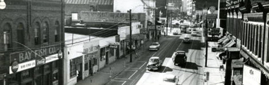
Description: This project recreates an Atlanta city block – specifically Decatur Street at Central Avenue (where Classroom South is now) – to show the historical view of the space as it looked in the 1920’s – 1930’s. The goal is to showcase an interactive space where students can experience it as though they were ‘walking through’ it in the past. In order to recreate the space, the 3D Atlanta team is using archived photographic material to render each building. A sample of the 3D environment is online, but eventually the environment will feature movement – including cars, streetcars, people, etc. The team is using maps of the period featuring shops, people, and objects, and will hopefully be able to feature narratives taken from real events (such as happenings at the 81 Theatre) for students to interact with. As a means to connect this project beyond GSU, this project is collaborating with students and faculty at Emory who are also working on a similar historical project.
For more on 3D Atlanta, visit the 3D Atlanta Page.
Contact:
Brennan Collins

Geotagging Atlanta
Description: As part of our efforts to map historic Atlanta, SIF fellows have been geo-tagging a collection of glass plate negative photographs from the 1920’s. These beautiful images provide rare glimpses into the area around the Five Points Metro Station, and are particularly noteworthy for showing a number of storefronts that would be submerged by the viaduct into what became known as “Underground Atlanta” just before construction began. After geo-tagging, these images can be used in a variety of ongoing SIF projects describing the development of Atlanta as an urban space, and be used to populate our 3-D virtual recreation of Atlanta.
For more on geotagging Atlanta, visit the Geotagging Atlanta page.
Contact:
Joe Hurley

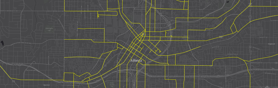
GSU Growth Map
Description: GSU Growth Map tracks 7 decades of GSU expansion, culminating with the University’s most recent expansion, the Georgia State, Georgia Perimeter consolidation. The GSU Growth Map is online now and will be updated continuously. To learn more about Georgia State’s expansion take a look at the comprehensive timeline available on the university’s website.
Contact:
Joe Hurley
Unpacking Manuel’s
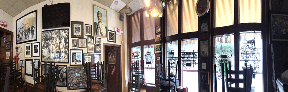
Description: Unpacking Manuel’s is a joint project between GSU, SCAD, Emory, Georgia Tech, and the owners of Manuel’s Tavern. The project was created in light of the forthcoming renovation of the building in order to preserve, using the latest technology, the original appearance of the interior of the historic Atlanta restaurant and bar. It also provides an opportunity for future research into the stunning collection of artifacts housed in the building and into the role Manuel’s Tavern has played in Atlanta history. SIF’s are helping to generate 3-D scans of the interior of the building using FARO laser scanners and are writing detailed descriptions of the material objects hanging on the tavern walls to preserve and document this Atlanta institution.
Contact:
Brennan Collins
PAST PROJECTS:
After Malcolm
Description: A joint project of Dr. Abbas Barzegar of Georgia State University and Dr. Bilal King of Morehouse College, After Malcolm is a resource for researchers, educators, and civic groups to explore Atlanta’s unique history of African American Muslim experiences. The After Malcolm website, built with SIF help, contains a series of archival materials and oral histories documenting Atlanta’s Muslim community.
Contact:
Abbas Barzegar
Atlanta Mass Transit
Description: This team has been trained in the use of ArcGIS Desktop to digitize and georeference historical planning documents of Atlanta’s mass transit system. They have chosen maps for digitization are chosen from the Planning Atlanta Collection which display plans specifically for rail transportation, other maps are digitized by project members using ArcMap. The tean is grouping digitized maps by decade and displaying them using Esri’s Story Map platform. The final map is available here.
Contact:
Joe Hurley
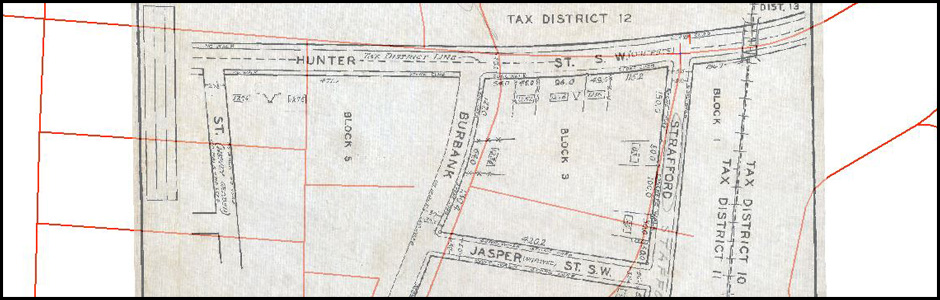
1934 Tax Map Project
Description: For this project, team members geo-referenced 30 tax maps, each showing a couple of blocks of 1934 Atlanta using Esri’s ArcMap 10.1 to turn the jpg files into geotiff (files which have geospatial data associated with them). The georeferenced maps are part of the GSU Library’s WPA Digital Collection.