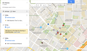
As the new school year kicks off so too does the ambition and drive to continue our projects as SIF moving with that same force. A now year long standing process, the 3D Atlanta project has really begun to take form, with now a prototype that wows people. As the details and content is added to the interactive 3d game engine, Unity, and the technical side of the project proceeds at a slower pace due to its tedious and time consuming nature, the research group is moving ahead. As a part of the research team on this project, the purpose and mission has been to scour the internet or any other resources available to find any useful images or interesting facts of the surrounding area during the time (1930s). This has been a large task and as each researcher had previously taken off on their own journey for wholesome historical content, we began to note how chaotic and unruly all these files, images, articles, and data can be hard to manage. Through this struggle, I began to use a very well known tool, Google Maps. Through This I have been able to create layers of each time period and since the interactive environment is based on geographic accuracy to the time period, I began to place the images, if possible in the exact location where the image was taken, or the place of which the article was written about.
Since this method the team has begun to realize how useful it is to see such data in a spatial sense. We can begin to see clusters of data in places which might retain more historical value and is appropriate to the period. The objective is to create an easily accessible pipeline of resources once the modeling crew has completed on street, they can then move onto another street from which the researchers have gathered a substantial amount of data. This makes it easier for the modeling/tech team to hash out streets due to their amount of content. Below:
In addition to this useful tool for organizing such data, I have come into a few complications:
- Google my maps prohibits the use of more than 10 Layers
- The image might get too busy
- there is no simple download or view larger function once you view the small pop-up unless you click on the image link.
- google my maps is not a usual place to store such data
With these complications, I have been wondering if there is a better way to spatially organize such historical data? With that question I am stuck to believe that maybe such research tool would be useful to develop or create? or has such a tool already been created that I am not aware of?
Feel free to comment with any advice or input of the subject!
until next time,
Alexandra Orrego
