A Sewage Water Wonder: Historic Fourth Ward Park

In this post, I will give an exterior built environment description on Historic Fourth Ward Park. All photos were taken from my cellphone.

Historic Fourth Ward Park (H4WP) is a multi-use outdoor green space that is accessible by people of all ages.

Location

The space is located north on Ralph McGill Boulevard and south of North Avenue. The best way to enter the park via street is from North Ave. Since the park is directly behind Ponce City Market, visitors can use its flag tower or orange logotype as a marker. There is also a short trail that connects to park to the Eastside Beltline.

North Avenue entrance, facing Ponce City Market.

A lawn sign that promotes supporting the Park.

Unlike other city parks in Atlanta, H4WP lacks proper signage at the two most popular entrances. Guests who stroll the park wouldn’t know the name until seeing this lawn sign.

Parking is available to visitors, but it is very limited. The developers may have done this to encourage walking , cycling, or utilizing to the park. If it is necessary to drive, be mindful that cars are bound to a narrow street with parallel parking.


Features

Lake at Historic Fourth Ward Park

The central characteristic of the park is the man-made lake. A winding trail encompasses the water and provides a closer view of the native plants, ducks, and two waterfalls. This loop can be accessed by a single ramp and a series of staircases.

Other features include an open recreational field, an amphitheater, and a playground with a splash pad. This versatility suggests a wide range possible use that may include: exercise groups, concerts (formal and informal), festivals, field trips, or simply, a day in the park. It would be best to use these features in warmer weather,  but the park is open all year long.

Layout

This portion of the park was adopted by Mandarin Oriental, Atlanta.

Historic Fourth Ward Park is built in two warped, concentric circles that allows individuals to take a stroll, exercise, or simply sit in a serene environment. Unique design features also add to the visual aesthetic of the park. Aside from beauty, these stone features were placed to guide rain water to the lake to prevent flooding.

After viewing H4WP on Google Maps, I realized it extends beyond what I viewed in person. The park appears to be split a multiple sections. Despite limited parking, the additional tracts of grass can accommodate a large number of people for a one day event. All areas of the park can be accessed via winding concrete sidewalks.

 

Exterior Built Environment- Annotated Bibliographies

In today’s post,  I will provide annotated bibliographies for sources related my study on an external built environment, Historic Fourth Ward Park.

A Greener Future

Burns, Rebecca. “A Greener Future.” Atlanta 55.2 (2015): 78. MasterFILE Elite. Web 5 Feb. 2016.

Rebecca Burns discusses the public parks of Atlanta in “A Greener Future”. Currently, Atlanta trails behind other cities in the United States when comparing land use designated to public parks. The creation of the Atlanta Belt Line has made the city more willing to address this concerns and make progress in transforming “brownfields” (vacant lots) into accessible parks for surrounding communities.

The transformation of Historic Fourth Ward Park.

Source: Historic Fourth Ward Park Conservancy The ten year transformation of Historic Fourth Ward Park.

Public parks have the ability to shape a community, with positive intentions. City planners claim parks, a man-made feature, induce a closer-knit feel and subtly encourage interactions within a population.

This one page spread is directly related to Historic Fourth Ward Park, as it was recently developed during the construction of the eastern Belt Line. During my research, this was the first magazine source that I had come across and it fits the selected exterior built environment. The site of the park also has a role in the history of Atlanta, that will be later explained in the bibliography of “Vale of Amusements”.

Even though the article focuses on the need for parks in Atlanta, Burns fails to mention the sprawling development around the new green spaces. “A Greener Future” was prepared for an audience that will be most likely to visit a park. Given the subject matter of the articles published in Atlanta, the target readers would fall into the mid-20s through mid-40s who have a median income above $30,000. This group has a higher chance of taking their children out to the park, visiting a restaurant along the Beltline, or exercising outside away from their home.

Pioneers of Gentrification: Transformation in Global Neighborhoods in Urban America in the Late Twentieth Century

Hwang, Jackelyn. “Pioneers Of Gentrification: Transformation In Global Neighborhoods In Urban America In The Late Twentieth Century.” Demography 53.1 (2016): 189-213. Business Source Complete. Web. 6 Feb. 2016.

Jackelyn Hwang studied the “rise of immigration” in the United States from the years after 1965 in her peer-reviewed article, “Pioneers Of Gentrification: Transformation In Global Neighborhoods In Urban America In The Late Twentieth Century.”

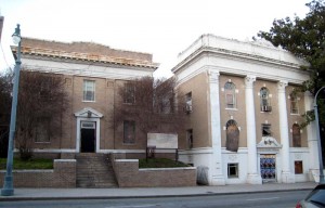
The dilapidated and abandoned office of the Atlanta Life Insurance Company, which is located in Sweet Auburn.

Source: Atlanta Time Machine The dilapidated and abandoned office of the Atlanta Life Insurance Company, which is located in Sweet Auburn.

The text displays several comparisons among race, primarily focusing only on white, black, Asian, and Hispanic populations. She used the classifications to determine if correlations between race and gentrification within a community was present. Hwang’s study revealed that low-income, minority neighborhoods are not likely to be affected by gentrification.

Old Fourth Ward falls east of downtown Atlanta and has a large black population. While some areas of the neighborhood has gentrified, other sites equate to the research. These sections contain buildings or lots that have been vacant for years.

Since Atlanta is an international destination for people around the world, it is essential to document the settling of the city. Anyone studying how immigrant population affect a society would find this source useful. I used this source because the demographics of Atlanta is complex and shifting, and gentrification would play a role in shaping  Old Fourth Ward.

Vale of Amusements: Modernity, Technology, and Atlanta’s Ponce de Leon Park, 1870–1920

Toton, Sarah. “Vale of Amusements: Modernity, Technology, and Atlanta’s Ponce De Leon Park, 1870–1920.” Southern Spaces. Robert W. Woodruff Library, 15 Jan. 2008. Web. 05 Feb. 2016.

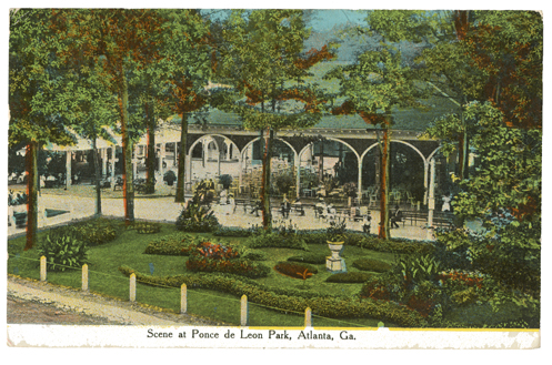
In “Vale of Amusements: Modernity, Technology, and Atlanta’s Ponce De Leon Park, 1870–1920”, Sarah Toton provides a historical analysis of the rise and fall Ponce de Leon Park. The article features elements of classism and racism that supports relations among people in Atlanta, and in the South as a whole. As it was modeled after parks in larger cities, such as New York’s Coney Island, Ponce de Leon Park was originally exclusive to the elite and prohibited people of color, unless they were servants. The park was the epitome of a built environment since it was a heavily regulated space.

Source: Southern Spaces A postcard of Ponce de Leon Park.

Source: Southern Spaces
A postcard of Ponce de Leon Park.

This source gives detailed accounts of the land that is now Historic Fourth Ward Park (my exterior environment), and the surrounding areas: Midtown Place and Ponce City Market. The currently mixed-used properties has a adverse history that is now unrecognizable.

With this source, I could study the change of the land use for the area and examine the needs of the people in the are over decades of time.