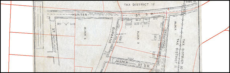
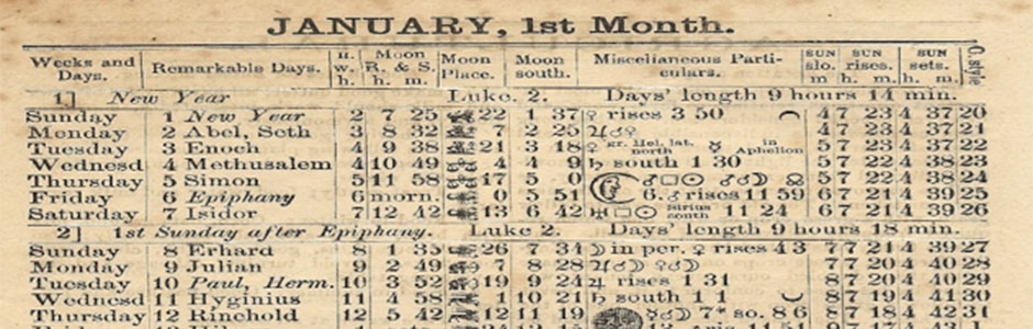
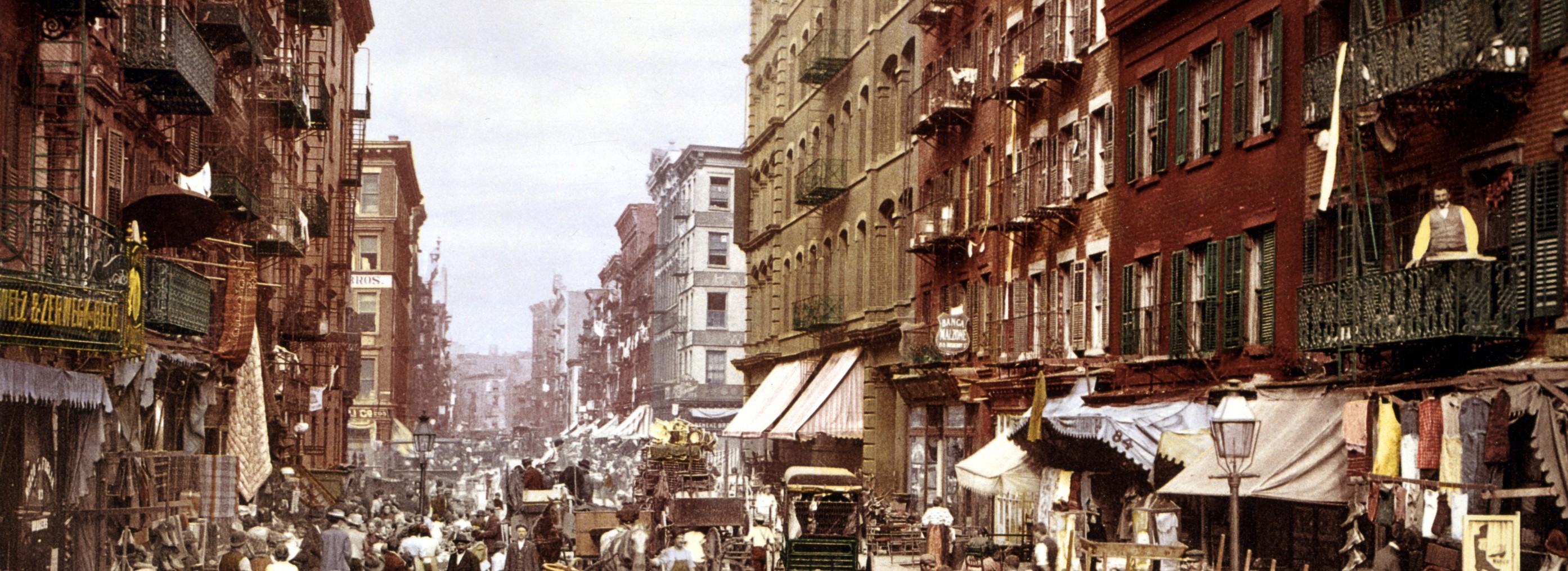
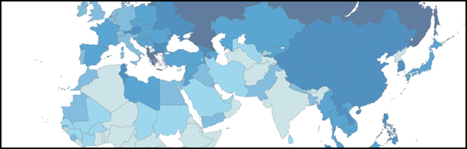
1934 Tax Map Project
Description: For this project, the each team member has been tasked with geo-reference 30 maps from 1934. Each map shows a couple of blocks of Atlanta’s street network. More specifically, we are using Esri’s ArcMap 10.1 to turn the jpg files into geotiff (files which have geospatial data associated with them). Once everyone has completed their geo-referencing, we will attempt to mosaic the entire collection to create one large 1934 map of Atlanta.
Contact:
Joe Hurley
 3D Modeling
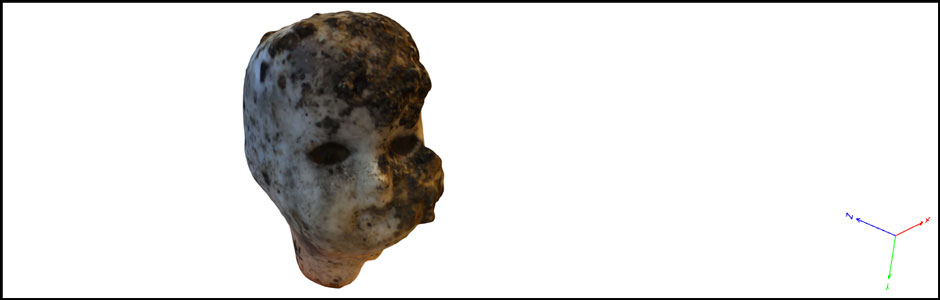
Description: A number of projects engage students in creating 3D digital models of real-world objects. In one course, for example, students in Dr. Robin Wharton’s expository composition class contributed to the Phoenix Project as part of a semester-long interdisciplinary examination of material culture. Using Agisoft’s Photoscan, students generated 3D models of historical artifacts excavated during the construction of the Metro Atlanta Rapid Transit Authority (MARTA) rail lines. They then drew upon their experience with the objects and their independent research to compose detailed essays explaining what each object is, how it appears to the senses, and what occurrence of events could have led the object to Georgia State University. Student work from the course was presented in Spring of 2015 at the Southern American Studies Association biennial conference in Atlanta and the Computer Applications in Archaeology conference in Siena, Italy.
Contact:
Robin Wharton
 3D Atlanta
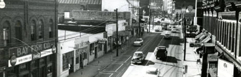
Description: This project recreates an Atlanta city block – specifically Decatur Street at Central Avenue (where Classroom South is now) – to show the historical view of the space as it looked in the 1920’s – 1930’s. The goal is to showcase an interactive space where students can experience it as though they were ‘walking through’ it in the past. In order to recreate the space, the 3D Atlanta team is using archived photographic material to render each building. Eventually the environment will feature movement – including cars, streetcars, people, etc. The team is using maps of the period featuring shops, people, and objects, and will hopefully be able to feature narratives taken from real events (such as happenings at the 81 Theatre) for students to interact with. As a means to connect this project beyond GSU, this project is collaborating with students and faculty at Emory who are also working on a similar historical project.
Contact:
Brennan Collins
 Aerial Mapping

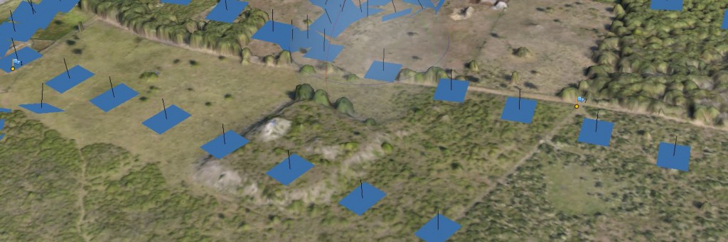
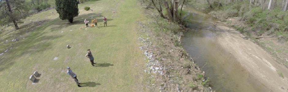
Description: Combining expertise with Robotics well as High End computing resources available in CURVE, Student Innovation Fellows were able to perform multiple 3d scene reconstructions at a landscape scale. By combining thousands of aerial images captured by Unmanned Aerial Systems in 3D “Structure From Motion” or SfM software, Student Innovation Fellows are able to generate Point Clouds, Digital Elevation Models and Meshes in incredible detail. These reconstructions have applications in Archaeology, Geosciences and Historic Preservation.
Contact:
Katie Price
Jeffrey Glover
Almanac Archive
Description: Dr. Lindsey Eckert has been examining and recording the notes people have been making over the centuries in physical library copies of almanacs. The goal of the Almanac Archive is to create a searchable, digital corpus of high-resolution images from these annotated almanacs to encourage research questions about the relationship between historical events, individuals’ everyday lives, and the materiality of Romantic-era interfaces for tracking time. For this project, this SIF team was heavily involved in the requirement analysis, user experience design and usability concerns and road map of the product through meetings and deliberations. They made design decisions as to which platform to use, XAMPP or .NET., and we explored implementation feasibility of the database design provided by Dr. Eckert.
Contact:
Lindsey Jane Eckert
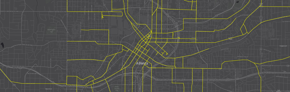 Atlanta Mass Transit
Description: This team has been trained in the use of ArcGIS Desktop to digitize and georeference historical planning documents of Atlanta’s mass transit system. They have chosen maps for digitization are chosen from the Planning Atlanta Collection which display plans specifically for rail transportation, other maps are digitized by project members using ArcMap. The tean is grouping digitized maps by decade and displaying them using Esri’s Story Map platform. The final map will be made available to the public as a way to contribute to the current dialogue around Atlanta’s public transportation systems.
Contact:
Joe Hurley
 Audio Virtual Reality Project
Description:This project focuses on establishing virtual reality gaming environments for the visually impaired community. SIF fellows are developing a virtual reality environment for the Oculus Rift that utilizes audible cues and gaming scripts, allowing users to experience virtual worlds without relying on sight. Our demo game will include menus, an active game where the player will learn the game environment, and a passive game where the player will be tested on their knowledge of the game’s settings and objects. For an early demo, click here.
Contact:
Glenn Gunhouse
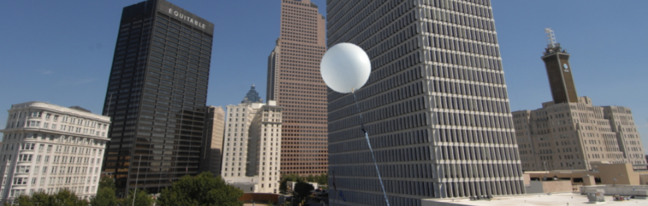
Climate Lab Weather Balloon
Description: The SIF team is providing technical expertise to make way for new experimental possibilities in GSU’s largest science class, Geography 1112, which enrolls over 1500 students annually. As part of SIF’s active learning pedagogy initiatives, designed to support innovatative, dynamic, and active educational techniques at Georgia State University, SIF Fellows are collaborating with faculty from the Department of Geosciences to launch a weather balloon high above the 28 story 25 Park Place Building. This balloon will contain instrumentation allowing students in Geography 1112 to study weather and atmospheric pressure in hands-on, real-world ways and directly engage in scientific observation and experimentation.
Contact:
Brennan Collins
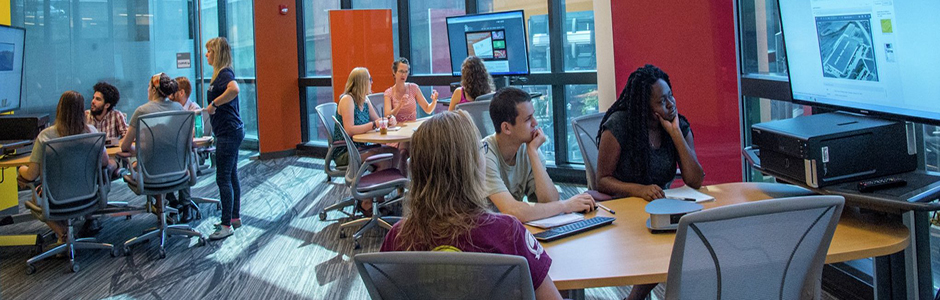
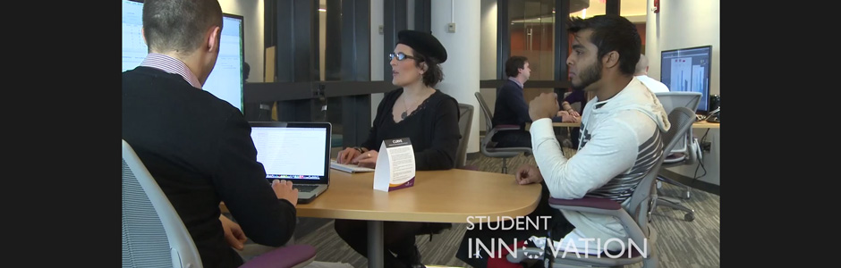
CURVE Outreach Project
Description: CURVE (Collaborative University Research & Visualization Environment) is a $1.2 million dollar research facility located on the 2nd floor of Library South on GSU’s Downtown Atlanta campus. The centerpiece at CURVE is the interactWall, a touch enabled, 24-foot-wide video wall designed for collaborative research. Seven additional collaborative workstations, including an advanced 4K workstation, feature high-powered PCs and Mac Pros allow groups to work with and manipulate large images and datasets.
Considering the substantial investment in this space, it’s important that students are aware of it as a resource and use it, and the CURVE Outreach project is designed to ensure just that. Through the creation of printed collateral, videos and more, CURVE is becoming well known throughout the university and region.
Contact:
Brennan Collins
Joe Hurley
Digital Champions & Activate Hybrid Pedagogy Videos
Description: The Digital Champions team is creating a short promo video for hybrid coursework through the Digital Champions grant. Their objective is to raise awareness among GSU faculty about hybrid courses and the corresponding grant. It features, for example, Dr. Gladys Francis who uses unconventional methods such as asking students to create tweet-length summaries of readings in French. By creating this short, the team is distilling a large amount of information into a more attractive visual package so that the target audience can understand the project through a short, attractive, punchy medium. This video will encourage more faculty to apply for the grant and be a part of the project. Hybrid Pedagogy Interviews are a video series featuring faculty and students who have experience with 1/2 online and 1/2 face-to-face classes. The series covers a variety of subjects (best practices, avoiding pitfalls, balance, etc.) of both faculty who have taught these courses, as well as students who have taken them. This semester the team focused on faculty interviews, and next will focus on student interviews. These videos will also work as a resource to explain how hybridity can work for students. The goal is to encourage more faculty members to incorporate hybridity into their current pedagogies.
Contact:
Brennan Collins
George Pullman
 Hoccleve Archive
Description: The Hoccleve Archive team is working to create a digital variorum/critical edition of the works of the Middle English poet, Thomas Hoccleve, especially his magnum opus, the many thousand line long Regiment of Princes, which survives in over 40 contemporary manuscripts. The history of Hocclevean textual scholarship ranges from late Medieval and early Modern scribal and manuscript communicative technologies, through the era of early print and into the 1980’s, when Hoccleve’s poems were the subject of a very early digital-humanities. The team aims to preserve these. Hoccleve’s last project was never completed, but it generated a large corpus of electronic material, which the team houses and is working to make available both as an archival resource and as a tool for the third aspect of the project, which is to create a digital pedagogy platform that will allow students and teachers to help build a critical edition.
The Hoccleve Archive is a digital database that contains more information and where you can see the web design and formatting we performed throughout the semester. The Hoccleve Archive will be launching its new website by Spring 2015 semester’s end. Among its features will be a digital edition of approximately three dozen poems from the original medieval manuscripts, and several digital humanities projects related to Hoccleve.
Contact:
Robin Wharton
Online Deliberation Mapping Tool
Description: This project is designed to provide instructors and students with a tool to curate, monitor and administer asynchronous student-created deliberations online. Similar to already available tools such as debategraph.org and AGORA, our application gives users the ability to agree, disagree and question posts made during a deliberation process. It also allows users to analyze the development of deliberations using time sliders to show how these deliberations have developed over time. This team’s goal is to create a stable online environment for classroom use based on deliberation activities.
Contact:
Justin Lonsbury
Heidi Beezley
Will Kerr
Physics Active Learning
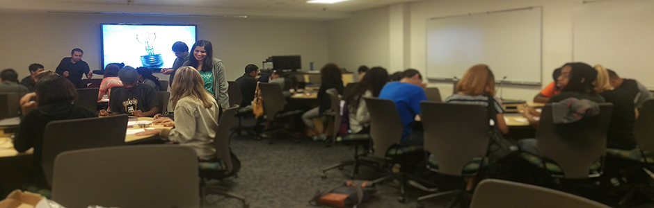
Description: The Physics Active Learning Team aims to prepare undergraduate and graduate teaching assistants (TAs) to be highly effective instructors in active learning laboratory environments. Teaching in active learning classrooms can be an adjustment for instructors who have no experience learning in these types of classrooms. Through interventions such as teaching observations, individual feedback, and roleplaying exercises, this project instills TAs with the pedagogical and technological skills necessary to be transformational educators in undergraduate physics classrooms. The outcome of this work will provide a model for training teaching assistants in STEM disciplines as higher education moves increasingly toward the active learning model.
Contact:
Brennan Collins
Online U.S. History Survey
Description: This project seeks to develop and produce a completely online course and curriculum using custom software and content. SIF work on the project has helped to re-conceptualize the multi-media textbook at the heart of the class, develop a number of video modules, and an array of remediation quizzes designed to improve comprehension of class material. Most of this material is already in use in the current hybrid version of the course, which will go completely online in the fall of 2015.
Contact:
Jeff Young
Tobacco Ebook
Description: The School of Public Health, using the Tobacco Centers of Regulatory Science grant, has asked this SIF team to make an Ebook of their book on the effects of tobacco. The book is titled Principles of Tobacco Control: Extinguishing the Habit. Much of the work the Tobacco Ebook team is doing is layout and design using iBooks Author and Tableau. Using Tableau, the team is able to take the data provided and recreate charts and graphs that include custom color palates, consistent visuals, so that the visuals are not previously copyrighted materials, but are beautiful and well designed. The team is pushing Tableau to its limits from a graphic design standpoint to accomplish visual requirements. When Tableau doesn’t do the job, they use Adobe Illustrator, or other software to make infographics.
Contact:
Justin Lonsbury
Will Kerr
Tools Wiki
Description: Students have access to a dizzying array of online tools to help them achieve their classroom goals. The Tools Wiki project is creating a custom GSU portal that seeks to list and organize many of these online tools based on the task they are best suited for. Students are able to search by task, such as blogging or presentations, and discover multiple tools designed for each task. The Tools Wiki provides a user friendly interface to access and review tools for the following categories: Blogging, Collaboration, Presentations, Mapping, File Storage, Timelines, Videos, and Websites.
Contact:
Brennan Collins
Unmanned Aerial Systems Hyrdology Project
Description: Student Innovation Fellows provided technical support to the Georgia State University Watershed Hydrology and Geomorphology Laboratory, including UAS hardware support and maintenance, piloting and pilot training for their investigation into the use of small UAS as a low cost, high resolution survey tool. This training, requested by Dr. Katie Price for students of her graduate seminar, exposed a number of students to the use of UAS as a tool for scientific research, including one student who has chosen to use UAS in his Masters Thesis. The project was initially presented by Dr. Price at the European Geophysical Union, and the research is ongoing in the Geosciences Department.