Diem, J.E., T.C. Hill, R.A. Milligan. 2018. Diverse multi-decadal changes in streamflow within a rapidly urbanizing region. Journal of Hydrology 556:61-71.
The impact of urbanization on streamflow depends on a variety of factors (e.g., climate, initial land cover, inter-basin transfers, water withdrawals, wastewater effluent, etc.). The purpose of this study is to examine trends in streamflow from 1986 to 2015 in a range of watersheds within the rapidly urbanizing Atlanta, GA metropolitan area. This study compares eight watersheds over three decades, while minimizing the influence of inter-annual precipitation variability. Population and land-cover data were used to analyze changes over approximately twenty years within the watersheds. Precipitation totals for the watersheds were estimated using precipitation totals at nearby weather stations. Multiple streamflow variables, such as annual streamflow, frequencies of high-flow days (HFDs), flashiness, and precipitation-adjusted streamflow, for the eight streams were calculated using daily streamflow data. Variables were tested for significant trends from 1986 to 2015 and significant differences between 1986–2000 and 2001–2015. Flashiness increased for all streams without municipal water withdrawals, and the four watersheds with the largest increase in developed land had significant increases in flashiness. Significant positive trends in precipitation-adjusted mean annual streamflow and HFDs occurred for the two watersheds (Big Creek and Suwanee Creek) that experienced the largest increases in development, and these were the only watersheds that went from majority forest land in 1986 to majority developed land in 2015. With a disproportionate increase in HFD occurrence during summer, Big Creek and Suwanee Creek also had a reduction in intra-annual variability of HFD occurrence. Watersheds that were already substantially developed at the beginning of the period and did not have wastewater discharge had declining streamflow. The most urbanized watershed (Peachtree Creek) had a significant decrease in streamflow, and a possible cause of the decrease was increasing groundwater infiltration into sewers. The impacts of urbanization on streamflow within the metropolitan area have undoubtedly been felt by a wide of range of communities.
Diem, J.E., 2013. The 1970 Clean Air Act and termination of rainfall suppression in a U.S. urban area. Atmospheric Environment 75:141–146.
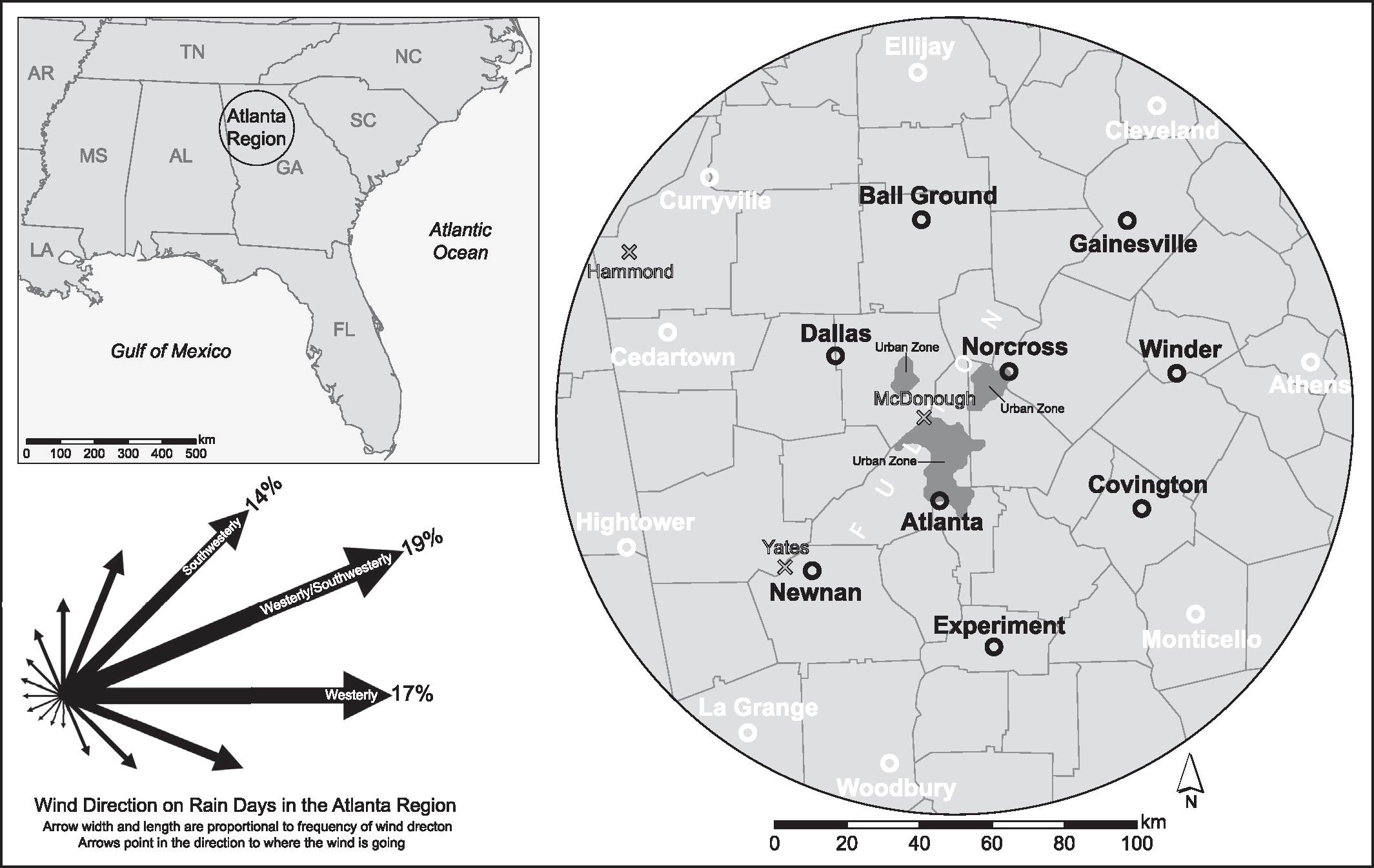
The purpose of this paper is to determine the impact of reduced atmospheric particulate resulting from the Clean Air Act of 1970 on changes in summer rainfall in the Atlanta, Georgia USA region. In order to determine if rainfall at nine candidate stations in the metropolitan area was influenced by changes in particulate concentrations within the 1948–2009 period, predicted rainfall characteristics were derived from rainfall frequencies at nine reference stations located more than 80 km from downtown Atlanta. Both parametric and non-parametric tests were used to test for significant differences between observed values and predicted values within 34 overlapping 30-year periods. For the country as a whole, emissions of PM10 (i.e. particulates with a diameter less than or equal to 10 μm) decreased by approximately 40% from 1970 to 1975. The reduction in emissions caused a rapid rebound in summer rainfall in the Atlanta region. There was suppression of rainfall over and downwind of the Atlanta urbanized area during 30-yr periods that comprise all or portions of the decades of the 1950s, 1960s, and 1970s. This suppression occurred even while urban-related factors that promote rainfall enhancement were present. During the 1948–1977 suppression period, there was a decrease in rainfall of at least 40 mm at affected locales, which is substantial given that the mean seasonal rainfall was approximately 300 mm. The rainfall suppression involved a decrease of heavy-rainfall days. Atlanta is most likely not a unique case; therefore, particulate-induced rainfall suppression might have occurred over and downwind of other U.S. urban areas prior to the late 1970s.
Diem, J.E. 2008. Detecting summer rainfall enhancement within metropolitan Atlanta, Georgia USA. International Journal of Climatology 28:129–133.
This paper presents a methodology for detecting summer rainfall enhancement within a metropolitan area. The chosen study domain is the Atlanta, Georgia USA metropolitan area, and the time period covers summer (i.e. June–August) seasons from 1949 to 2005. In order to determine if observed heavy-rainfall frequencies at nine candidate stations in the metropolitan area are enhanced, predicted frequencies are derived from heavy-rainfall frequencies at seven reference stations located more than 50 km from downtown Atlanta. Both parametric and non-parametric tests are used to test for significant differences between observed frequencies and predicted frequencies within 29 overlapping 30 year periods (i.e. climatological periods). Norcross, which was ∼30 km northeast of downtown Atlanta and thus was typically downwind of urbanized Atlanta on heavy-rainfall days at all candidate stations, was the only station to exhibit significant rainfall enhancement. The final ten climatological periods exhibited enhancement, with observed frequencies of ≥ 30 mm days for those periods being at least 20% larger than predicted frequencies. It is hoped the methods employed in this paper can be used in other metropolitan areas.
Diem, J. E. 2006. Anomalous monsoonal activity in central Arizona, USA. Geophysical Research Letters 33, L16706, doi:10.1029/2006GL027259.
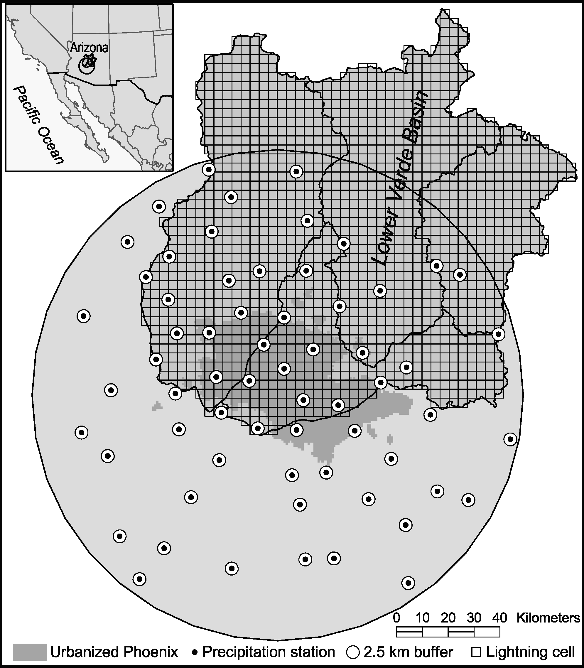
Published research has suggested that urban and agricultural activities in central Arizona may be enhancing monsoonal precipitation in the region; therefore, this study employed cloud-to-ground lightning data and topographic data to reveal spatially anomalous zones of lightning activity in central Arizona. A multiple linear regression model with topographic variables as predictors explained 85% of the variance in gridded lightning-flash counts. Clustering of large positive residuals of lightning flashes existed between 40 km and 100 km north/northeast of urbanized Phoenix. Observed lightning flashes in this zone were ∼40% more frequent than lightning flashes predicted by the model. Two plausible causes of the enhanced lightning activity are intensified convective storms due to Phoenix-derived water vapor and altered microphysical processes in storm clouds due to Phoenix-derived atmospheric pollution. It is possible that the positive-anomaly zone also had enhanced rainfall.
Diem, J.E., C.R. Ricketts, and J.R. Dean. 2006. Impacts of urbanization on land-atmosphere carbon exchange within a metropolitan area in the USA. Climate Research 30:201–213.
Urbanization can cause changes in carbon fluxes, which, in turn, impacts atmospheric carbon dioxide (CO2) concentrations and possibly global surface temperatures. Using the Atlanta, Georgia, region as a case study, this paper explores the impact of urban expansion from 1973 to 2002 on land-atmosphere carbon exchange. The major objectives were to estimate net ecosystem production (NEP) values for multiple land-cover classes and to link urbanization-induced changes in land-cover to changes in NEP and overall carbon fluxes. The principal data were daily climatic data, year-specific land-cover data, annual net ecosystem exchange (NEE) values, and annual anthropogenic carbon emissions estimates. The principal methods were testing for climatic trends, determining the composition of the land-cover classes, estimating annual NEP values for the land-cover classes, and estimating the overall carbon exchange. The major findings: (1) there were no significant trends for any of the climatic variables; (2) the region was only ~16% urbanized in 1973; however, by 2002, the region was ~38% urbanized; (3) the NEP in 1978-1980 of 443 g C m-2 yr-1 may have continued until 1996-1998, despite the substantial loss of forest land; and (4) net carbon emissions increased from ~150 g in 1978-1980 to ~940 g C m-2 yr-1 in 1996-1998. Therefore, urban expansion greatly increased the carbon emissions of the Atlanta region; however, it is possible that, through increasing the growing-season length as well as increasing nitrogen and CO2 fertilization, urban expansion may not decrease the region-wide NEP.
Diem, J.E., and T.L. Mote. 2005. Inter-epochal changes in summer precipitation in the southeastern United States: Evidence of possible urban effects near Atlanta, Georgia. Journal of Applied Meteorology 44:717–730.
Through modification of the planetary boundary layer, urbanization has the potential to have a significant impact on precipitation totals locally. Using daily summer-season precipitation data at 30 stations from 1953 to 2002, this study explores the possibility of urban effects as causes of spatial anomalies in precipitation in a zone within 180 km of Atlanta, Georgia. The time period is divided into consecutive epochs (e.g., 1953–77 and 1978–2002), and interepochal differences in precipitation totals, heavy-precipitation days, cumulative heavy precipitation, and atmospheric conditions are explored. The southern stations experienced significant decreases in precipitation, whereas significant precipitation increases occurred at central/west-central stations. The most striking increases occurred at Norcross, Georgia, which is ∼30 km northeast of downtown Atlanta; Norcross had the third smallest number of heavy-precipitation days during 1953–77, but, during 1978–2002, it had the most heavy-precipitation days. Not only did the amount of urban land cover upwind of Norcross increase substantially from the earlier to the later epochs, but regionwide dewpoint temperatures also increased significantly. Therefore, it is suspected that the increased precipitation at Norcross was caused by urban effects, and these effects may have been enhanced by increased atmospheric humidity.
Diem, J.E., L.B. Coleman, P.A. DiGirolamo, C.W. Gowens, N.R. Hayden, E.E. Unger, G.B. Wetta, and H.A. Williams. 2004. Comments on “Rainfall modification by major urban areas: Observations from spaceborne rain radar on the TRMM satellite.” Journal of Applied Meteorology 43:941–950.
Diem, J.E., and D.P. Brown. 2003. Anthropogenic impacts on summer precipitation in central Arizona, USA. The Professional Geographer 55:343–355.
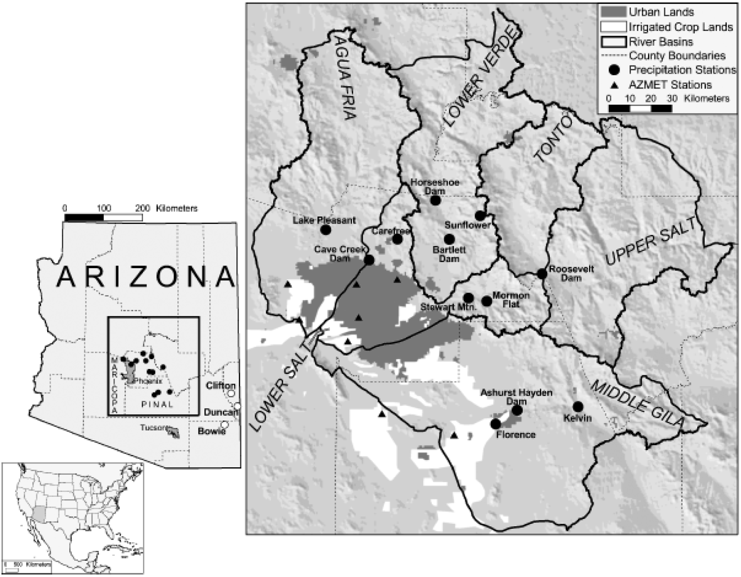
This article explores the possibility of urbanization- and irrigation-induced increases in summer precipitation totals in central Arizona. Maximum precipitation impacts are hypothesized to occur downwind of the Phoenix area in the Lower Verde basin. Results from statistical tests indicate that summer precipitation totals in the Lower Verde basin are greater than totals in nearby basins. Precipitation totals in the basin also appear to be equivalent to totals at more monsoon-impacted stations in eastern Arizona. While this research is preliminary, the results do provide encouraging evidence of the existence of anthropogenically enhanced summer precipitation in central Arizona.


