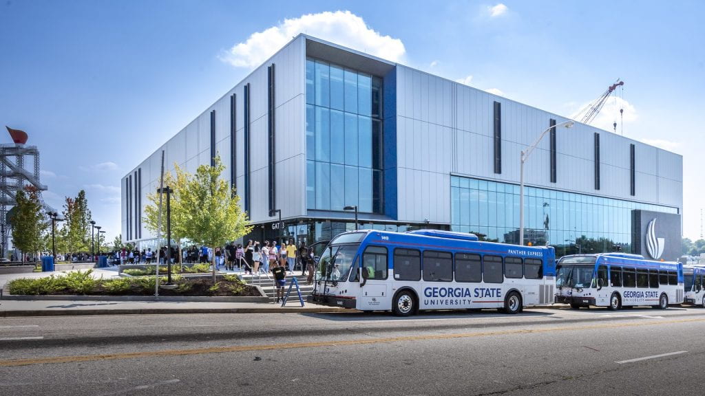
In 2020 contractor Brassfield & Gorrie broke ground to build Georgia State University’s Convocation Center.2 This premier facility has already been incorporated into GSU’s operations, hosting athletics and graduation ceremonies, among many other events. Occupying an entire block across from GSU’s Blue Lot, its presence looms large in Summerhill. The center has yet to see a class from freshman convocation through commencement, and this newness raises a question: how did GSU acquire the land, and what was there before?
An “Athletics Neighborhood”
The Convocation Center is bracketed by Pollard Boulevard SW, Capitol Avenue SE, and Fulton Street SW. GSU acquired this property in a major 2017 purchase that included what is now Center Parc Stadium (formerly Turner Field, home of the Braves). According to the Atlanta Journal-Constitution, the Georgia State University Foundation and Carter and Oakwood Development were co-buyers for the 67 acre site.3 The agreement gave GSU control over 38 acres.4 The Atlanta Fulton County Recreation Authority sold the site for $30 million.5
Georgia State Athletics Director Charlie Cobb told the Georgia State University Magazine that, “The idea is creating an athletics neighborhood.”6 This “neighborhood” will in time include football at Center Parc, basketball at the Convocation Center, and baseball and softball where Blue Lot is currently.7 Compacting athletics into a single district near the main campus area is meant to increase student engagement by making it easier to get to games.
There is a common theme in the coverage of this development plan:
“Georgia State University’s new Convocation Center doubles the arena it replaces and is expected to give a shot in the arm to a long-neglected Atlanta neighborhood.”
Building Design & Construction article, headline linked on Convocation Center’s homepage8
“we are excited to be moving forward with a plan that will be transformative for the city and for Georgia State,”
Former Georgia State President Mark P. Becker9
“The aim is to bring back life to some of the city’s oldest neighborhoods.”
J. Scott Trubey, The Atlanta Journal-Constitution10
These excerpts accomplish two things. First, they show Atlanta’s continued desire to rebuild and rebrand itself. GSU is lauded for the developments that add to the city’s modern image. Second, and most notable, they characterize the Summerhill area as derelict and lifeless—a “long-neglected” neighborhood that needs to be brought “back [to] life.”11
The question is, why? If someone were to walk around Summerhill, they would likely agree that GSU’s sports facilities are the area’s main characteristics. What of Summerhill in the time before GSU bought huge swaths of land—was it simply barren?
A Residential Neighborhood
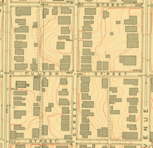
Before the downtown connector was built, this area was two separate blocks. The block where the Convocation Center stands was bordered on the south by Fulton Street, on the east by Capitol Avenue, on the north by Clarke Street, and on the west by Crew Street.
The area was primarily residential for a long time. Dating back to 1899, the Sanborn Fire Insurance Maps show that this block consistently served as a block for dwellings, which are marked with a D.
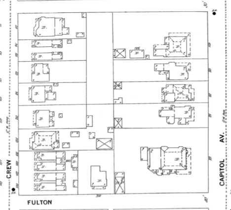


The progression of these maps conveys several factors of the nature of the block. The 1899 map depicts smaller buildings with a large X over them. This is the marking for a stable. The 1932 map shows no stables, but some of the larger houses have garages (labeled “A” for auto), and the later map shows that a gas station was built in the northeastern corner. These successive developments point to the growing importance of automotive transportation in everyday life.
The dwellings are mainly duplexes and small homes arranged in tight clusters. They are also drawn as frame buildings or frame buildings with some brick inclusions. Frame was not preferred because of its susceptibility to fire damage. This layout suggests that it was a working-class area. The 1937 maps released after the redlining process also suggest this, labeling the area’s inhabitants as mainly, “skilled mechanics, factory workers, and laborers.”16
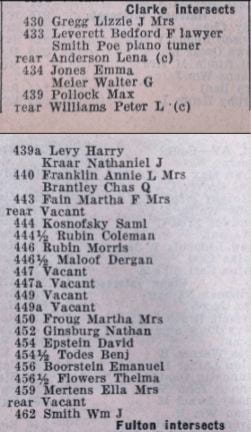
Further information on the residents can be gleaned from the city directories. The city directories around this time period designated black households with a (c) for colored. The entries below are from the 1934 city directory. While there are a couple black households near Clarke Street, the block was predominantly white. It is also worth noting the number of vacancies listed. Prior directories have fewer vacancies; many people became unable to afford their homes.
The Sanborn maps, the redlining document, and the city directory lead to the conclusion that this block was home to white working class Atlantans for several decades—a residential neighborhood where GSU’s “athletics neighborhood” now stands.
Changing Times
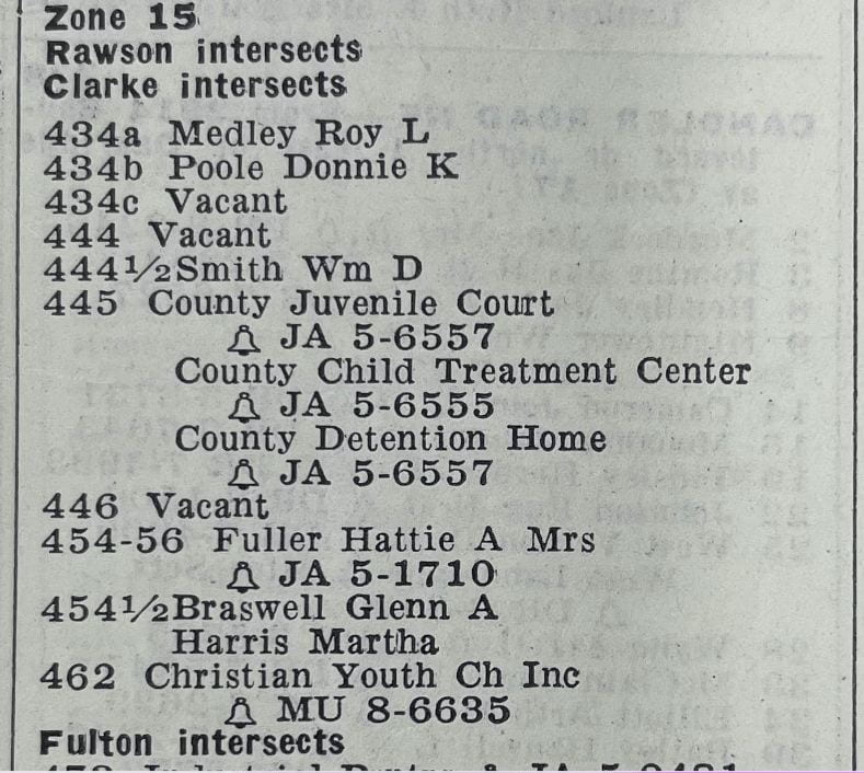
Moving forward, the 1961 city directory shows that the usage of this block pivoted. A large chunk of the block was taken up by the County Juvenile Court, the County Juvenile Detention Center, and the County Detention Home. In other words, the block switched from housing residences to housing government buildings, and they were still surrounded by vacancies.
Contextualized within the time frame, the increase in vacancies and the switch to government buildings can be attributed to the Great Depression.
These buildings were phased out as well. The juvenile justice buildings can now be found on the opposite side of the downtown connector. By 2008, the block was a parking lot.
Summerhill, Neglected
This progression explains why the lot of land was open for GSU to develop on, but not why the Convocation Center was considered necessary to “give a shot in the arm to a long-neglected Atlanta neighborhood.”20 Stand in front of the Convocation Center and face across Fulton Street—the reason becomes clear.
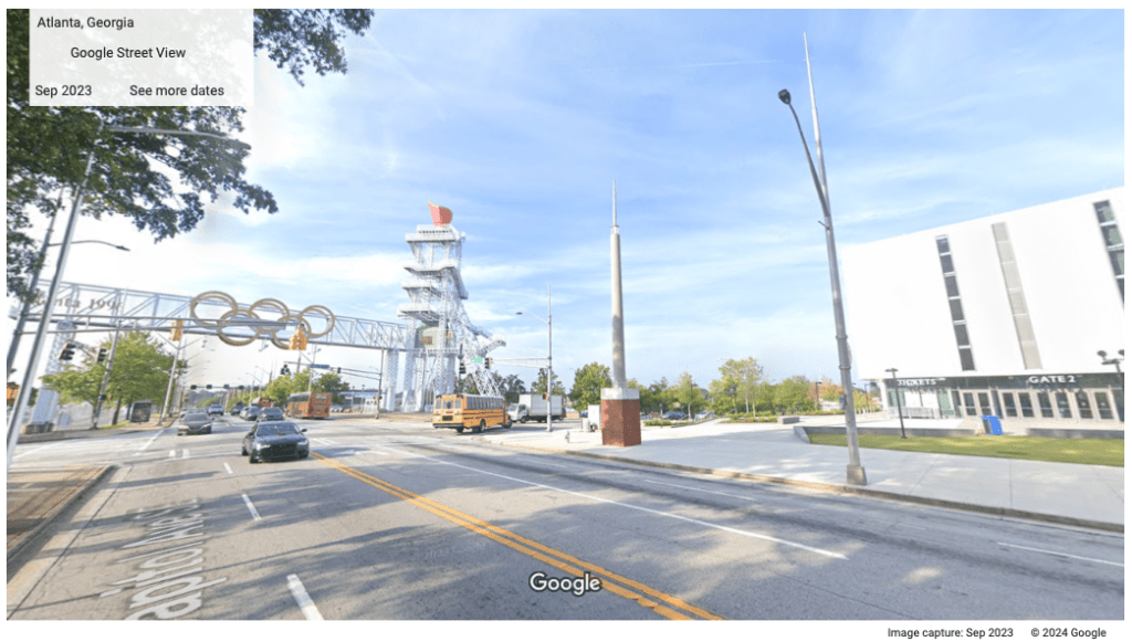
Summerhill was the primary stadium neighborhood for the 1996 Atlanta Summer Olympics.21 Due to the high-stakes international significance of the Olympics, the state of this area cannot be understood without its consideration. The 1937 redlining map marks most of Summerhill’s residential area, including the Convocation Center block, as “hazardous” or “definitely declining.”22 This characterization stuck to Summerhill for decades, and the Atlanta Olympic Committee (AOC) utilized it to create a successful bid to host the Olympics.23 In line with the Olympic Charter’s goal to “place sport at the service of the harmonious development of human kind,” the AOC’s application to the Olympic Committee leaned heavily on Atlanta’s past human and civil rights campaigns—promising that the benefits from being the host city would be “fairly and equitably apportioned.”24 The process of preparation for the Olympics that took place once the bid was won provides more insight into the state of Summerhill today.
The construction of the Atlanta-Fulton County Stadium had already significantly damaged the Summerhill population, and the AOC planned to build the Olympic stadium right next to it (read more here). There was a complex series of citizen opposition. The Atlanta Neighborhoods United for Fairness (A’NUFF) organized to represent the stadium-area neighborhoods and tried to raise objections to the planning.25 A’NUFF pushed for a transparent and accessible planning process, but they were unable to gain real traction or influence.26 The Atlanta Committee for the Olympic Games (ACOG) formed a “neighborhood task force” to attempt to address citizens’ concerns, yet they gave up on solving disagreements and disbanded the group after less than two months.27
In a move to gain some political leverage, the Summerhill Neighborhood Inc. (SNI) decided to support the stadium and cooperate with the AOC.28 SNI won some concessions and got Summerhill designation as the primary stadium-area neighborhood with the goal of receiving redevelopment funding.29
However, Summerhill was refused funding to improve local conditions by the ACOG, who replaced their human rights approach with one that emphasized a “corporate-sponsored games.”30
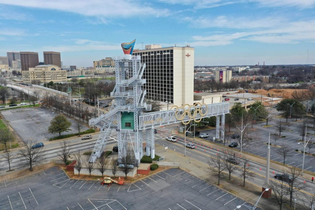
Where Did the Life Go?
Not only did Olympic development infrastructurally neglect Summerhill, the demographics of its residents were all but manually curated. Preparing for the international stage, Atlanta wanted to present an image of prosperity and progress, regardless of its reality.
Anti-homeless campaigns ramped up in preparation for the Olympics. Harsh and broad ordinances were passed, even prohibiting “reclining in particular places.”32 A new city jail was built, and when Olympic officials would visit, large groups of unhoused people were arrested to be removed from the officials’ radar.33 Many unhoused people were also made to take one-way tickets out of the city.34
Summerhill’s housed residents were also forced out. Since there was no focused effort to protect the local community, Olympic redevelopment simply priced out the low-income residents who made up the majority of Summerhill.35 New townhouses and single-family homes went up, and 60 households were displaced.36 The Olympics committees would rather have vacant homes than risk their prim and perfect image.
What Lies Beneath the Convocation Center?
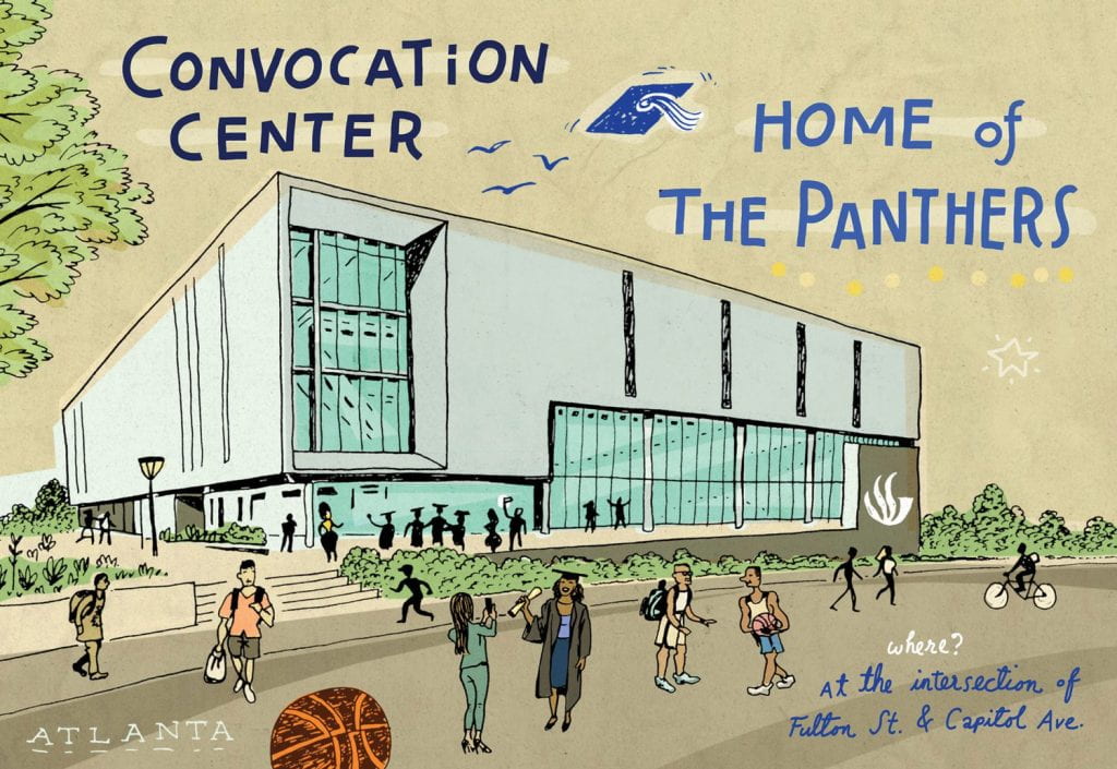
Georgia State University’s Convocation Center takes up 200,000 square feet of Summerhill.38 The building may be fresh, but the ground beneath it is not. The center sits atop a lengthy legacy from the block’s 19th and 20th century working class residences, to the switch to government buildings, to the Olympics completely redirecting Summerhill’s developmental path. Before there was an “athletics neighborhood,” there was an actual, residential neighborhood. The Convocation Center is needed to revitalize a “lifeless” neighborhood only because the neighborhood was rendered lifeless by Olympic displacement.
In a couple days’ time, GSU’s class of Spring 2024 will cross the Convocation Center’s stage to receive their diplomas.
- “About the Center.” Georgia State University. https://convocationcenter.gsu.edu/about/ (accessed April 8, 2024). ↩︎
- Ibid. ↩︎
- Janel Davis, “Turner Field deal with Georgia State signals ‘new beginning’.” The Atlanta Journal-Constitution, Aug 18, 2016, https://www.ajc.com/news/local-govt–politics/turner-field-deal-with-georgia-state-signals-new-beginning/k2SR464r9bB1sYUEMIJxMN/ (accessed April 24, 2024). ↩︎
- “Georgia State, Private Development Venture Finalize Acquisition Of Turner Field Site.” Georgia State News Hub. https://news.gsu.edu/2017/01/05/georgia-state-private-development-venture-finalize-acquisition-of-turner-field-site/ (accessed April 23, 2024). ↩︎
- Davis, “Turner Field deal with Georgia State signals ‘new beginning’.”
↩︎ - Michael Davis and John Dykes, “Spreading Roots.” Georgia State University Magazine. https://news.gsu.edu/magazine/spreading-roots (accessed April 23, 2024). ↩︎
- Ibid. ↩︎
- Peter Fabris, “Georgia State University Convocation Center revitalizes long-neglected Atlanta neighborhood.” Building Design & Construction. https://www.bdcnetwork.com/georgia-state-university-convocation-center-revitalizes-long-neglected-atlanta-neighborhood (accessed April 23, 2024). ↩︎
- “Georgia State, Private Development Venture Finalize Acquisition Of Turner Field Site.” ↩︎
- J. Scott Trubey, “Georgia State, partners close deal for Turner Field.” The Atlanta Journal-Constitution, Jan 5, 2017, https://www.ajc.com/news/local-govt–politics/turner-field-sale-georgia-state-and-partners-marks-new-chapter/s2S96lmTxYhGBWfM0pMHXI/ (accessed April 23, 2024). ↩︎
- Fabris, “Georgia State University Convocation Center revitalizes long-neglected Atlanta neighborhood”; Trubey, “Georgia State, partners close deal for Turner Field.” ↩︎
- “Explore.” ATL Maps. https://atlmaps.org/projects/explore (accessed April 8, 2024). ↩︎
- Sanborn Map Company, “Atlanta 1899, Sheet 94” Digital Sanborn Maps. https://digitalsanbornmaps-proquest-com.eu1.proxy.openathens.net/browse_maps/11/1377/6152/6515/97169?accountid=11226 (accessed April 23, 2024). ↩︎
- Sanborn Map Company, “Atlanta 1931-1932 vol. 3, 1932, Sheet 322.” Digital Sanborn Maps. https://digitalsanbornmaps-proquest-com.eu1.proxy.openathens.net/browse_maps/11/1377/6155/6525/98068?accountid=11226 (accessed April 23, 2024). ↩︎
- Sanborn Map Company, “Atlanta 1924-Mar. 1962 vol. 3, 1932-Aug. 1950, Sheet 322” Digital Sanborn Maps. https://digitalsanbornmaps-proquest-com.eu1.proxy.openathens.net/browse_maps/11/1377/6156/6530/98510?accountid=11226 (accessed April 23, 2024). ↩︎
- “Atlanta, Georgia.” Mapping Inequality: Redlining in New Deal America. https://dsl.richmond.edu/panorama/redlining/map/GA/Atlanta/area_descriptions/D12#loc=15/33.7365/-84.3831 (Accessed April 8, 2024). ↩︎
- 1934 Atlanta City Directory. (Atlanta: Foote and Davis Co, 1934), 1267-1293. ↩︎
- Ibid. ↩︎
- 1961 Atlanta City Directory. (Atlanta: Foote and Davis Co, 1961), 106. ↩︎
- Peter Fabris, “Georgia State University Convocation Center revitalizes long-neglected Atlanta neighborhood.” ↩︎
- Keating, Larry. “Downtown Redevelopment During the Olympics Era.” In Atlanta: Race, Class And Urban Expansion, 164–93. Temple University Press, 2001. http://www.jstor.org/stable/j.ctt14bszqm, 164. ↩︎
- “Atlanta, Georgia.” Mapping Inequality: Redlining in New Deal America. ↩︎
- Chandra D. Ward, “Atlanta and Other Olympic Losers.” Contexts 12, no. 3 (2013): 46–51. http://www.jstor.org/stable/24710797. ↩︎
- Ibid. ↩︎
- Larry Keating, “Downtown Redevelopment During the Olympics Era.” In Atlanta: Race, Class And Urban Expansion, 164–93. Temple University Press, 2001. http://www.jstor.org/stable/j.ctt14bszqm, 167. ↩︎
- Larry Keating, “Downtown Redevelopment During the Olympics Era,” 169. ↩︎
- Larry Keating, “Downtown Redevelopment During the Olympics Era,” 168. ↩︎
- Larry Keating, “Downtown Redevelopment During the Olympics Era,” 174. ↩︎
- Ibid. ↩︎
- Chandra D. Ward, “Atlanta and Other Olympic Losers.” ↩︎
- Sarah Dylla, “Stop 1 | Atlanta’s Olympic Cauldron.” Atlanta History Center. https://www.atlantahistorycenter.com/programs-events/public-programs/olympic-paralympic-games-celebration/sites-and-venues-of-96/atlantas-olympic-cauldron/ (accessed April 25, 2024). ↩︎
- Seth Gustafson, “Displacement and the Racial State in Olympic Atlanta: 1990–1996.” Southeastern Geographer, vol. 53, no. 2, 2013, pp. 198–213. JSTOR, http://www.jstor.org/stable/26229061. (accessed March 7, 2024).
↩︎ - Ibid. ↩︎
- Ibid. ↩︎
- Ibid. ↩︎
- Ibid. ↩︎
- Michael Davis and John Dykes, “Spreading Roots.” ↩︎
- “About the Center.” Georgia State University. ↩︎
