
Sometimes, researching an object becomes akin to following Alice’s white rabbit. I catch glimpses through the trees – a foot, an ear, a worried paw holding a shiny gold watch – and yet the whole picture scampers further away with each attempt to catch it. If this seems an odd metaphor to use, I think an example of such an object may show how apt it actually is.
In a corner in the secondary bar area of Manuel’s Tavern there are a pair of street signs affixed to the wall. They read “WILLIAMS MILL RD. N.E.”, in black letters on an aged white background. Most people would likely overlook the signs, not knowing that this sign, and the road it once marked, plays a part in several of the largest events in the history of this neighborhood in Atlanta. 
The signs are easy to miss, hidden in a corner below the windows in the second bar’s table area. But they caught my eye as I was going through and cataloging the many, many objects, because I remembered that the street that borders the north side of Manuel’s is Williams Mill Rd. N.E., and something else about the name set my brain digging through memories.
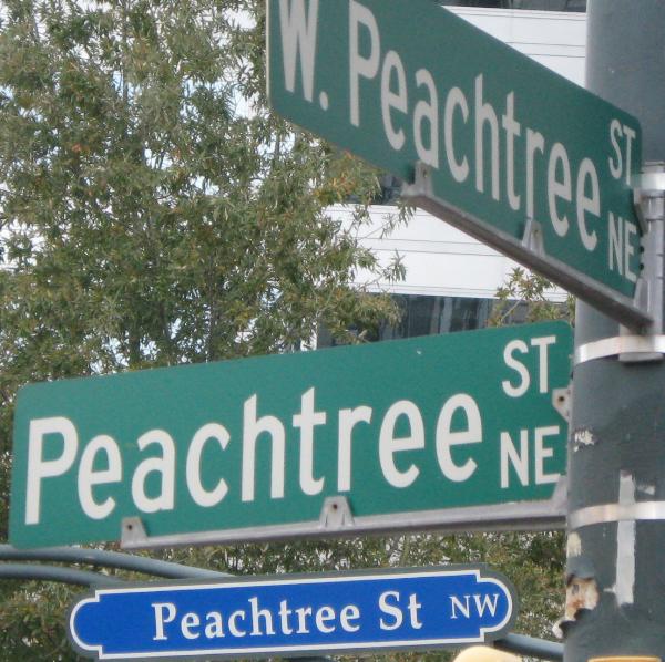 Most visitors to Atlanta will remember that all street signs in Atlanta are either green or blue with white letters, as illustrated by this example. Normal signs are generally green, while signs that hang across streets or at intersections are blue with white borders. But this hasn’t always been the case. Prior to the introduction of the green and blue signs, there was a huge variety of sign types used throughout the city, primarily varying by either county or neighborhood. The signs in question are of a fairly common type from Dekalb county, and were ubiquitous enough that I remember a few last stragglers in Inman Park during the mid 1980s.
 That places these as having been in place sometime before the 1980s, but photographic evidence places signs of this type as early as the 1960s. And there, my brain reminded me of an odd bit of geography. William’s Mill is a very odd road, starting at North Highland Ave and traveling south-southwest until it dead ends at an odd angle into Linwood Ave. N. E. just at the edge of the Freedom Parkway greenspace. It turns out that Williams Mill Rd. N.E. was one of the roads massively truncated by the proposed creation of I-485.
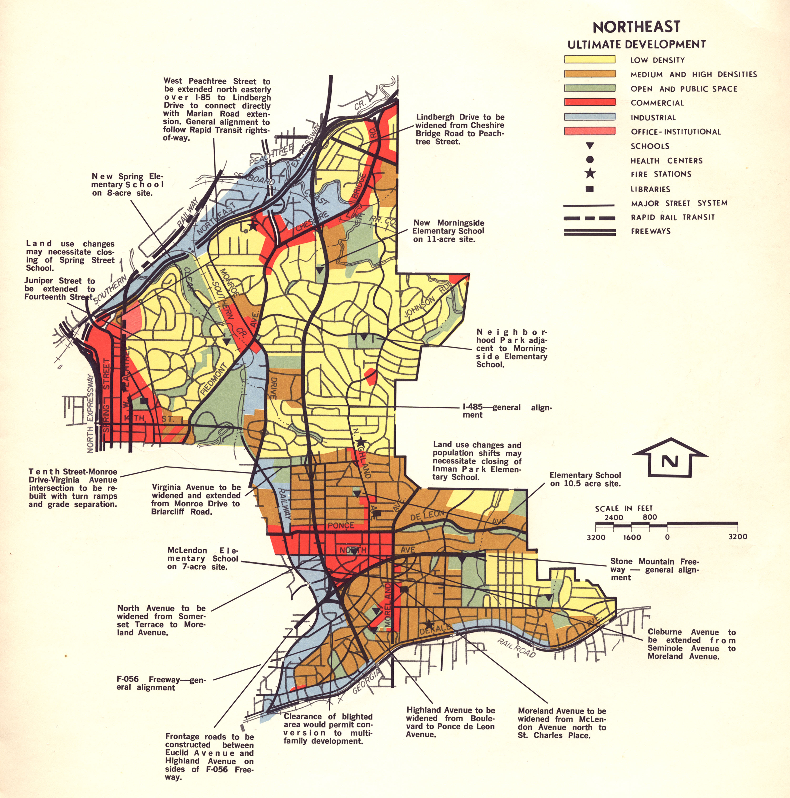
Map of proposed routes for the I-485, SR400, and the various changes the plan required.
Proposed in 1964, I-485 was to be a 5.9 mile long highway that would have begun at the I-75/I-85 Connector, and extended along SR 410 east until intersecting with SR 400, then turned north to end near Lindbergh Dr. – a huge swath of interstate through the middle of a residential neighborhood. The changes this would have wrought to the area would have been enormous. Looking closely at the above map, it is easy to see where a large section of Williams Mill Rd. was simply demolished in the hope of creating this highway. Claiming eminent domain, the city began seizing and purchasing land for the proposed road. However, the neighborhoods most affected by this sought to fight back. In light of the proposed construction, the residents of Morningside-Lenox Park rebelled. Thus began a chapter in Atlanta history known as the Atlanta freeway revolts. This period marked the creation of the Morningside Lenox Park Association (which still exists today), the rise of powerful and unified neighborhood associations in Atlanta, as well as the large swath of “empty” lots which once sat where Freedom Parkway and the Carter Library are today.
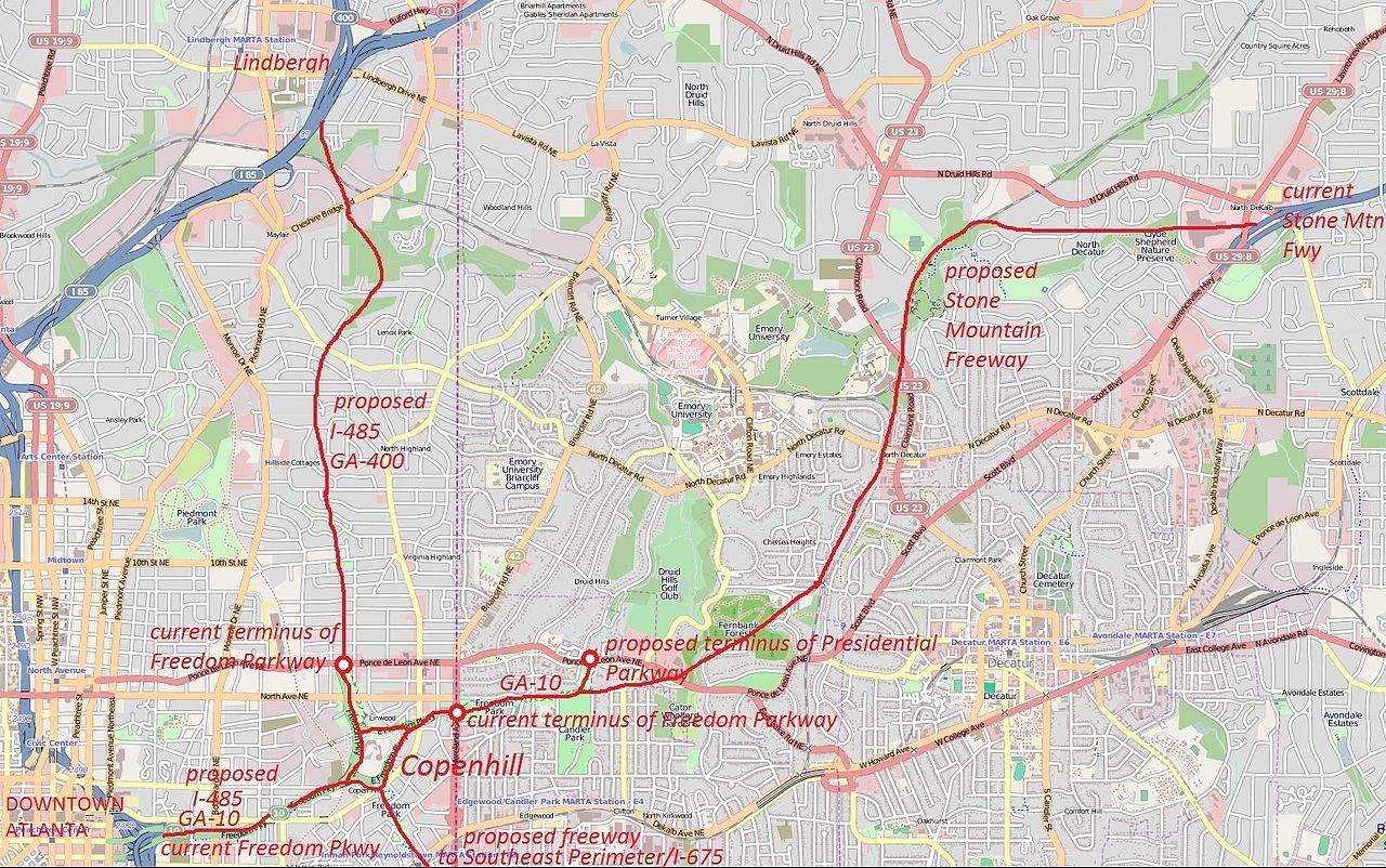
I heard about this time in Atlanta’s history from my parents many times as I was growing up. I remember standing at the intersection of E. Morningside Dr., E. Rock Springs, and N. Morningside Dr. and being told by my dad that the city had once wanted to put a freeway directly over that intersection (see the above map near where the words “proposed I-485 GA400 are” to locate the intersection in question). It would have meant a highway less than a quarter mile from where I lived, bisecting the neighborhood like a canyon. Even now, thinking about it, I get slightly sick feeling.
But this isn’t the whole of the story of this little road that borders the Tavern. Next time, I’ll trace the road even further back into Atlanta’s history, and explain how this road, and two other stub roads miles away, one at Peachtree St. and one at Emory University, were once all the same road.
