As a parent, teacher, or student, why should I care about Geospatial Technologies and GIS?
Lucrative and in-demand careers and research opportunities await!
Geospatial technologies have recently been identified as a high-growth industry by the U.S. Department of Labor. Within geospatial technology fields, the projected employment growth from 2010 to 2020 of geoscientists is 21 percent, environmental engineers is 22 percent, and computer systems analysts is 22 percent (U.S. Department of Labor, 2012). Although these career opportunities are growing at a dramatic rate, U.S. high school students are often unaware of these opportunities until later in their college careers as most U.S. high schools are not adequately preparing students for these careers given that geography, geospatial technology, and Geographic Information Systems (GIS) courses are not prominently offered in most of the nation’s high schools. You can learn these in-demand technology skills during our Academy!
Geospatial Technologies and Geographic Information Systems Defined:
The Geospatial Workforce Development Center at the University of Southern Mississippi defines the geospatial technology industry as “an information technology field of practice that acquires, manages, interprets, displays, analyzes, or otherwise uses data focusing on the geographic, temporal, or spatial component.” It also includes system and database development and management practices for these information technologies. Geographic Information Systems (GIS) are the most prominent form of geospatial technology. The Environmental Systems Research Institute (ESRI, 2014) defines GIS as an integration of “hardware, software, and data for capturing, managing, analyzing, and displaying all forms of geographically referenced information. It allows users to view, understand, question, interpret, and visualize data in many ways that reveal relationships, patterns, and trends in the form of maps, globes, reports, and charts.”
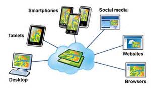
A diagram explaining the role of multiple technologies in mapping…from ESRI, 2012.

An online mapping project focused on understanding sustainability and green infrastructure.
Learn more about geospatial technologies and Geographic Information Systems at www.gis.com
Apply now using our Google Form application process at:
https://docs.google.com/forms/d/149VBCHMwif8foDRi34hiEeLEh_6rGTZDVROPlobszf4/viewform?usp=send_form